International Journal of Scientific & Engineering Research, Volume 6, Issue 2, February-2015 1015
ISSN 2229-5518
Morphometric Analysis of Drainage Basin through GIS: A Case study of Sukhna Lake Watershed in Lower Shiwalik, India.
YangchanJ1, Jain A.K.2, Tiwari A.K2, and Sood A3
Abstract: Land, water and soil are limited natural resources and their widely utilization with increased population is a major concern. To mitigate the increasing demand of land and water resources, it is of prime important to conserve the natural resources for sustainable de- velopment. Morphometric analysis provides a quantitative description of drainage system which is an important aspect of watershed char- acterization. Morphometric analysis of Sukhna Lake watershed located in Chandigarh covering Punjab and Haryana was carried by using GIS technique. Survey of India topographic sheets in 1:50,000 scales and Arc GIS 9.3 software were used for analysis. Drainage map was
prepared with the help of GIS (Geographic information System tool) and the Morphometric parameters such as linear, aerial and relief as- pect of the watershed have been determined based on the formula suggested by Horton, Strahler,. The analysis of linear aspects of drain- age basin shows that the basin has a dendritic pattern with fifth order stream. Bifurcation ratio of basin(4.113 to 4) falls under the range (3.0 and 5.0) in which the geologic structures do not distort the drainage pattern. Drainage density, drainage texture, elongation ratio and
relief ratio value of Sukhna watershed was 3.435Km/Km2 and 9.30 confirms that the study area is underlain by impermeable subsurface
material of Siwaliks having sparse vegetation and hilly relief and steep slopes with very fine texture causes prone area of soil erosion risk in the Sukhna Lake watershed.
Key words: Morphometric analysis, GIS, watershed.
—————————— ——————————
1 INTRODUCTION
IJSER © 2015 http://www.ijser.org
International Journal of Scientific & Engineering Research, Volume 6, Issue 2, February-2015 1016
ISSN 2229-5518
and is a precious resource as it is the physical base of biomass on the earth. Conservation of such type of natural resources is important to miti-
gate the increasing demand of land and Water resources (Panhalkar, S.S.etal 2012). According to National Bureau of Soil Survey & Land use Planning report (NBSS, 2005) about 146.82 million hectares area is reported to be suffering from various kinds of land degradation .The study of the watershed Morphometric analysis provides the beneficial parameters for the assessment of the ground wa- ter potential zones, identification of sites for water harvest- ing structures, water resources management, runoff and geographic characteristics of the drainage system (Aravin- da,P.T and Balakrishna,H.B 2013).The quantative morpho- metric analysis of drainage system is an important aspect of characterization of watersheds(Kanth, T.A., and Zahoorul Hassan 2012). Morphometry is the measurement and math- ematical analysis of the configuration of earth’s surface and of the shape and dimensions of its landform provides the basis of the investigation of maps for a geomorphological survey (Panhalkar, S.S., and Pawar, C.T., 2011). The mor- phometric parameters are classified into three i.e. Linear, Relief and Areal. These parameters are extracting from Geo information Environment (Kartic Bera and Jatisankar Ban- dyopadhyay., 2013). More recent study on morphometric analysis using remote sensing techniques was carried out by (Panhalkar, S.S. etal2012.Kanth, T.A., and Zahoor- ulHassan2012, KarticBera and JatisankarBandyopadh- yay.2013, Waikar, M.L and AdityaP.Nilawar 2014).
Remote sensing and GIS techniques are the proven efficient
tools in the declination, updating and morphometric analy- sis of drainage basin. The drainage basin analysis is im- portant in hydrological investigation like assessment of the ground water potential and ground water management. The present study was to describe the drainage characteris-

tics ofSukhnaLake Watershed located in Chandigarh and to carry out the morphometric analysis through GIS tech- niques to understand the hydrological behavior of the ba- sin.
2 Study Area:
The study area is located in the Union Territory of Chandi- garh and part of it located in Haryana and Punjab. The catchment area of 42.843 sq Km is drained by two seasonal rivulets i.e. Kansal and Nepli which originate in Haryana and are fed by number of rivulets to Sukhna Lake located in Chandigarh. It lies between Latitude 30045’0”N to
30049’0”N and Longitude 76049’0”E to 76053’0’’E (Figure1).
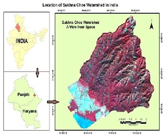
Figure 1.Location of Sukhna Lake watershed in India
The climate is semi arid with mean maximum temperature of 41.80 0C during June and minimum temperature of
5.100C during January. Average rainfall of the area is
1120mm with maximum of 2200 mm and minimum of
713mm. Out of the total rainfall during the year, 80% is re- ceived during monsoon season from July to September
(Grewal2009). The catchment areas are highly variable
IJSER © 2015 http://www.ijser.org
International Journal of Scientific & Engineering Research, Volume 6, Issue 2, February-2015 1017
ISSN 2229-5518
within short distance. Murthy and Shankaranarayana (1977) mapped the soils and Grewal and Juneja (1984) char- acterizes the soil of this catchment as erosive in behavior. The natural vegetation consists of trees, shrubs, climber and grasses. Apart of the natural vegetation so many other spe- cies plantation has also been done. The forest is the pre- dominant land use in the catchment which constitute of Shiwalik hills. The foot-hill area has agriculture, settlement and fallow land. This area falls in three villages namely Kaimbwala, (U.T. Chandigarh), Kansal (Punjab) and Saketri (Haryana). (Grewal 2009).
3. Material and Method:
In present study morphometric analysis was based on GIS technique. The delineation of Sukhna Lake water- shed and drainage network was done from SOI topograph- ical sheets no. H43K13, H43K14 of 2009 scale of 1:50,000 and by using ArcGIS 9.3 software.
The morphometric parameters such as stream or- der (U), stream length (Lu), mean stream length(Lsm), stream length ratio (RL), bifurcation ratio (Rb), mean bifur- cation ratio (Rbm), relief ratio (Rh), drainage density (Dd), stream frequency (Fs), drainage texture (Rt), form factor (Rf), circulatory Ratio (Rc), elongation ratio(Re) and length of overland flow(Lg) .The methodology for the calculation was based on the formula suggested by Horton [1945], Strahler [1964], Hardly [1961], Schumn [1956], Nookara- tanm et. al. [2005] and Miller [1953] which are mentioned in Table 1.
Table 1. Formulae adopted for computation of mor- phometric parameters
MorphometricParame-
ters
Formula Reference

IJSER © 2015 http://www.ijser.org
International Journal of Scientific & Engineering Research, Volume 6, Issue 2, February-2015 1018
ISSN 2229-5518
[1956]

Where; A = Area of the Basin (km2), Rf = Form Factor, Cc = Compactness Ratio, Dd = Drainagedensity, Lb = Length of Basin (km), Lb2=Square of the basin length, Lg=Length of overland flow, Lsm = mean
Stream Length, Lu=Total Stream length of order u, Nu =
Total number of stream segment of order u, Nu+1=Number of stream segment of next higher order, P=Perimeter (Km), R= Relief, Rb = Bifurcation Ratio, Rc =Circularity Ratio, Re= Elongation Ratio, Rh= Relief Ratio.
4. Result and Discussion
4.1 Morphometric analysis of basin:
Morphometric Analysis of a watershed provides a quantita- tive description of the drainage system which is an im- portant aspect of characterization of watersheds (Strahler,
1964). The various above morphometric parameters such as linear, areal and relief aspect were used for this present studies:
4.1.1 LINEAR ASPECT:
4.1.1.1 Stream order (Su) and Stream Number (Nu):
Stream ordering is the first step of quantitative analysis of the watershed. The stream ordering systems was first advo- cated by Horton, R.E., 1945 and further Strahler, A.N.,
1952a and 1952b modified in ordering system. In this study
Strahler, system was used to find the stream ordering. The smallest fingertip channel was designated as order 1. A channel segment of order 2 was designated where two first order channels join together and the process was continued further. The trunk stream, through which all discharge of water and sediment flown, was given by the stream seg- ment of highest order.
The total order wise stream segment is known as stream number. [Horton, R.E., 1945] states that numbers of stream segment of each order form an inverse geometric sequence with order num- ber. It was found that Sukhna Lake watershed had 5th order stream which includes 288 total stream numbers in the catchment, out of which
218 stream number was identified in 1st order, 53
stream number was in 2nd order, 12 stream num- ber in 3rd order, 4 stream number in 4th order and
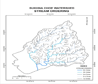
1 stream number in 5th order respectively shown in Figure 2. Drainage patterns of stream network for the basin have been observed as mainly den- dritic type which indicates the homogeneity in texture and lack of structural control.
Figure 2.Stream Orders in Sukhna Lake watershed
4.1.1.2 Stream Length (Lu):
The stream length has been computed based on the law proposed by (Horton, R.E., 1945).It was the total length in
the particular order. Generally, the total length of stream
IJSER © 2015 http://www.ijser.org
International Journal of Scientific & Engineering Research, Volume 6, Issue 2, February-2015 1019
ISSN 2229-5518
segment was maxmum in first order and decreased as stream order increases. The total stream length for Sukhna- Lake watershed was 146.44Km which includes 83.160Km in
1st order, 28.175 Km in 2nd order, 16.923 Km in 3rd order,
14.142 in 4th order and 4.037 Km in 5th order respectively shown in table (2). The Deviation may indicate flowing of streams from high altitude, variation in lithology or by high relief /moderately steep slopes. (Singh1997).
4.1.1.3 Bifurcation ratio (Rb):
Bifurcation ratio is the ratio of the number of the stream segments of given order ’Nu’ to the number of streams in the next higher order(Nu+1). (Schumn 1956).Horton con- sidered the bifurcation ratios is an index of relief and dis- section calculation. In the study bifurcation ratio varies from 4.113 to 4 and mean of bifurcation ratio for entire basin was 3.88 which is under range of 3.0 to 5.0 for basins detail shown in table(2).The values of basin falls under the range of bifurcation ratio in which the geologic structures donot distort the drainage patter (Kanth, T.A., and Za- hoorul Hassan 2012).
4.1.1.4 Mean Stream Length (Lum):
The Mean Stream Length of channel is a dimensional prop- erty and reveals the characteristic size of drainage network components and its contributing basin surfaces (Strahler
1964).It is obtained by dividing the total length of stream of order by total number of segments in the order. In this study Mean stream length varies from 0.381 to 4.037Km. It was observed that Lum was less for 1st order stream and it was gradually increased for the 5th order stream detail in table 2.This deviation may be due to variation in slope and topography.
4.1.1.5 Length of overland flow (Lg):
It is length of water over the ground before it gets concen- trated into definite stream channels. This factor relates in- versely to average slope of the channel and is quite synon- ymous with length of sheet flow to a large degree. It is ap-
proximately equals to half of reciprocal of drainage density (Horton, R.E., 1945).It was observed that length of overland flow for the Sukhna Lake watershed was 0.1456 shown in table 2.
Table 2: Result of linear aspects of Sukhna catchment:
S. No | Strea m Or- der (Su) | Strea m Num- ber (Nu) | Stream Length (Lu) | Bifur- cation Ratio (Rb) | Mean Strea m Lengt h (Lum) | Length of over- land Flow(L g) |
1 | I | 218.00 | 83.160 | | 0.381 | 0.1456 |
2 | II | 53.00 | 28.175 | 4.113 | 0.532 | 0.1456 |
3 | III | 12.00 | 16.923 | 4.417 | 1.410 | 0.1456 |
4 | IV | 4.00 | 14.142 | 3 | 3.536 | 0.1456 |
5 | V | 1.00 | 4.037 | 4 | 4.037 | 0.1456 |
| Total | 288.00 | 146.437 | 15.53 | 9.895 | 0.1456 |
| | | Aver- age | 3.106 | 1.98 | 0.1456 |
4.1.2 AERIAL ASPECT:
Areal aspects (Au) of a watershed of given order u is de- fined as the total area projected upon a horizontal plane contributing overland flow to the channel segment of the given order and includes all tributaries of lower order. The watershed shape has a significant effect on stream dis- charge characteristics, for example, the elongated water- shed having a high bifurcation ratio can be expected to have alternated flood discharge. But on the other hand, the round or circular watershed with a low bifurcation ratio may have a sharp peak flood discharge. The shape of a wa- tershed has a profound influence on the runoff and sedi- ment transport process. The shape of the catchment also governs the rate at which water enters the stream.
IJSER © 2015 http://www.ijser.org
International Journal of Scientific & Engineering Research, Volume 6, Issue 2, February-2015 1020
ISSN 2229-5518
Areal aspects include form factor, circularity ratio, and elongation ratio, drainage density, shape factor, com- pactness coefficient.
4.1.1.6 Form factor (Rf):
Horton defines the form factor Rf as a dimension- less ratio of watershed area (A) to the square of the length of the watershed (L). The value of form factor would al- ways be less than 0.7854 (for a perfect circular watershed). The watershed with higher form factor are normally circu- lar and have high peak flows for shorter duration, whereas elongated watershed with lower values of form factor have low peak flows for longer duration. For the study area of Sukhna Lake watershed form factor was 0.300 shown in table (3):
4.1.1.7 Circularity ratio (Rc)
Circularity ratio is the ratio between the areas of watershed to the area of circle having the same circumference as the perimeter of the watershed (Miller, 1953). It is influenced by length and frequency of stream, geological structure, land us/land cover, climate and slope of the basin. Circularity ratio value for the study area was obtained as 0.559 and it indicated the basin was characterized by moderate to low relief and drainage system seems to be less influenced by structural disturbances. The high value of circularity ratio shows the late maturity stage of topography. As the value falls under 0.2 to 0.8, greater the value more is the circulari- ty ratio. It is the significant ratio which indicates the stage of dissection in the study region. Its low, medium and high values are correlated with youth mature and old stage of the cycle of the tributary watershed of the region.( Aravin- da, P.T and Balakrishna, H. B., 2013).
4.1.1.8 Elongation ratio (Re)
Elongation ratio is the ratio between the diameter of the circle having the same area as the watershed and maximum length of the basin (Schumn, 1956).Values of Re varies from 0.6 to 1.0 over a wide variety of climate and
geologic types. Re values close to unity correspond to re- gions of low relief, whereas values which fall under the range 0.6-0.8 are usually associated with high relief and steep ground slope(Strahler 1964).The values can be classi- fied in three categories(1) circular(>0.9), (2) oval (0.9-0.8),(3) less elongated(<0.7). The Re values in the study area was
0.62 it indicate it was elongation in nature and it shown in table (3).
4.1.1.9 Drainage density (Dd):
According to the drainage density (Dd) is defined as the total length of streams per unit area divided by the area of drainage basin (Horton 1945). It is helpful in deter- mining the permeability and porosity of the watershed. It is also a good indicator of landform elements in stream erod- ed topography. Low drainage density leads to coarse drainage texture and vice versa. Generally, low drainage density results in the area of highly resistant subsoil mate- rial and high drainage density is the resultant of weak sub- surface material. In Sukhna watershed with drainage densi- ty value of 3.435Km/Km2, confirms the recognition that the study area was underlain by impermeable sub- surface ma- terial of Siwaliks having sparse vegetation and hilly relief.
4.1.2.5. Drainage Texture (Rt):
Horton (1945) defined drainage texture as the total number of stream segments of all order in a river basin to the perimeter of the basin. It is important to understand geomorphology which means that the relative spacing of drainage lines. Drainage texture can be classified into 5 dif- ferent textures i.e., very coarse (<2), coarse (2 to 4), moder- ate (4 to 6), fine (6 to 8) and very fine (>8) (Smith 1950). In the present study the watershed has a drainage texture of
9.30 means very fine texture and more risk of soil erosion.
IJSER © 2015 http://www.ijser.org
International Journal of Scientific & Engineering Research, Volume 6, Issue 2, February-2015 1021
ISSN 2229-5518
Table 3: Result of AREAL ASPECTS OF SUKHNA CATCHMENT
4.1.2 RELIEF ASPECTS
Relief is the difference in elevation between any two reference points. Relief measure of a region indi- cates the potential energy of a drainage system. A region having a high relief can transfer high energy into the drainage system. Maximum relief within a region is naturally the difference in elevation between the highest and lowest points.
4.1.2.2 Watershed relief:
Watershed relief is the difference in elevation be- tween the remotest point in the water divide line and the discharge point of the watershed.
H= (Difference in elevation of the highest point of water- shed) - (Difference in elevation of the watershed outlet)
The difference in elevation between the remotest point and discharge point is obtained from the available contour map
.The highest point of watershed was formed in elevation of
615 m above mean sea level. The lowest relief was obtained at outlet was 341 m above msl. The overall relief calculated for the watershed was 274 Km.
4.1.2.3 Relief ratio
The difference in the elevation of the highest and lowest points in a watershed is its total relief, whereas the ratio of basin relief to basin length (horizontal distance along the longest dimension of the basin parallel to the principal drainage line) is Relief Ratio (Rh) (Schunm, 1956). It is used to measure the overall steepness of a river basin and is an indicator of intensity of erosion processes operat- ing on the slopes of the basin. Normally, it has inverse cor- relation with drainage area and size of drainage basin. For the present study itobtains 23.03 shown in (Table 4)
IJSER © 2015 http://www.ijser.org
International Journal of Scientific & Engineering Research, Volume 6, Issue 2, February-2015 1022
ISSN 2229-5518
4.1.2.4 Stream Frequency (Fs)
The stream frequency is the total number of stream segment of all order per unit area (Horton
1945). The stream frequency of study area was
6.76 per square Km shown in table (4).
Table 4: RELIEF ASPECTS OF SUKHNA CATCHMENT
S.No | Morphometric Parameter | Formula | Result |
1 | Height of Basin Mouth(z)m above sea level (DEM) | | 341 |
2 | Maximum Height of the Basin (Z) m | | 615 |
3 | Total Basin Re- lief(H)Km | H=Z-z | 274 |
4 | Relief Ratio (Rhl) | Rhl = H/Lb | 23.03 |
5 | Ruggedness Number (Rn) | Rn=Dd*(H/1000) | 0.941 |
6 | Stream Fre- quency | | 6.757 |
5 CONCLUSION:
The morphometric analysis of Sukhna Lake water- shed using Geographic Information System retrieved that this tool helps to analysis the drainage basins easily and accurately in short time duration. The analysis of linear aspects of drainage basin result shows that the basin has a dendritic pattern with fifth order stream. The values of basin falls under the range (3.0 and 5.0) of bifurcation ratio in which the geologic structures do not distort the drainage
pattern. Drainage density and drainage texture value of
Sukhna watershed was 3.435Km/Km2and 9.30 confirms the recognition that the study area is underlain by impermea- ble subsurface material of Siwaliks having sparse vegeta- tion and hilly relief with very fine texture hence more risk of soil erosion. The analysis of elongation ratio and relief ratio indicates the drainage basin was elongated in nature with high relief and steep slopes causes risk of erosion in- tensity was more in this Sukhna Lake watershed.
6 Reference:
1. Aravinda,P.T and Balakrishna,H.B (2013). Morphometric analysis of Vrishabhavathi watershed using remote sensing and GIS. International Journal of Research in Engineering and Technology. Vol2 (8), pp 514-522.
2. Biswas S, Sudhakar S, Desai VR (1999). Prioritization of sub
watersheds based on morphometric analysis of drainage ba- sin - A remote sensing and GIS approach. J. Indian Soc. Rem. Sens., 27(3): 155–166. [8].
3. Grewal, S.S., (2009).Study on impact of Soil conservation
Measures in the catchment of Sukhna Lake on the Ground water, Soil and Geology. Bulletin of Society for Promotion and Conservation of Environment (SPACE)
4. Grewal, S.S., and Juneji, M.L., (1984).Studies on the erosion
behavior of the soil in the catchment of a rapidly silting Lake at Chandigarh. J.Soil conservation 12(1):58-65.
5. Hardely, R.F and Schumm, S.A.,(1961).Sediment sources and drainage basin characteristics in upper Cheyenne river ba- sin. United States. Geological survey water-supply paper,
1531-B pp. 10-19.
6. Horton, R.E., (1945). Erosional development of streams and their drainage density: hydro physical approach to quantita- tive geomorphology. Geol.Soc.Amer.Bull, no. 56, pp.275-370
7. Javeed,A., Khanday,M.Y., and Ahmed,R., (2009). Prioritiza- tion of Sub-watersheds based on morphometric and Land use analysis using remote sensing and GIS Techniques.Jour. Indian Soc. Remote Sensing, Vol. 37, pp.261-274
8. Kanth, T.A., and Zahoor-ul Hassan (2012). Morphometric analysis and watershed development prioritization of water- sheds for soil and water resources management in Wular
Catchment using Geo-spatial tools. International Journal of
IJSER © 2015 http://www.ijser.org
International Journal of Scientific & Engineering Research, Volume 6, Issue 2, February-2015 1023
ISSN 2229-5518
Geology, Earth and Environmental Sciences. Vol. 2(1), pp 30-
36.
9. KarticBera, and JatisankarBandyopadhyay., (2013). Prioriti- zation of watershed using Morph metric Analysis through Geo informatics technology: A case study of Dungra sub- watershed, West Bengal, India. International Journal of Ad- vances in Remote sensing and GIS. Vol.2 (1), pp 1-8.
10. Miller, V.C, (1953).A quantitative geomorphic study of
drainage basin characteristics in the Clinch Mountain area,
19. Strahler, A.N., (1952b). Quantatitative geomorphology. In: Fairbridge, R.W. (eds) .The encyclopedia of geomorphology, Reinhold Book Crop. New York.
20. Strahler, A.N., (1952a).Dynamic basis of geomorphology.
Bull. GeoL.SoC.Amer. Vol.63, pp.923-938.
21. Waikar, M.L. and AdityaP.Nilawar., (2014).Morphometric Analysis of Drainage Basin using Geographical Information system: A case study. International Journal of Multidiscipli-
nary and current research. Vol. 2, pp 179-184.i
Varginia and Tennessee. Project NR 389042, Tech.
i1and 2Department of Soil and Water Engineering, Ludhiana.
Rept.3.Columbia University, Department of Geology, ONR,
Geography Branch, New York.
11. Murthy, R.S., and Shankaranaryana, H.S., (1977).Utility of soil maps for watershed treatment in Shiwa- liks.J.IndianSoc.Soil Sci.25 (3):313-316
12. Nookaratanam, K, Srivastava, Y.K., Venkateswararao, V ., Amminedu,E., and Murthy, K.S.R.,( 2005).Check dam posi- tioning by prioritization of micro watersheds using SYI model and morphometric analysis – Remote sensing and GIS perspective. Journal of the IndianSociety of Remote Sensing,
33(1):25:28).
13. National Bureau of Soil Survey and Land Use Planning
(NBSSLUP), (2005), Annual Report.
14. Panhalkar, S.S. andPawar, C.T., (2011). Watershed Devel- opment Prioritization by applying WERM model and GIS techniques in Vedganga Basin (INDIA), ARPN Journal of Agriculture and Biological Science, pp 38-44.
15. Panhalkar, S.S., Mali, S.P., and Pawar, C.T
(2012).Morphometric analysis and watershed development prioritization of Hiranyakeshi Basin in Maharashtra, India. International Journal of Environmental Science, vol 3(1), pp
525-533.
16. Schumm, S.A., (1956).Evolution of drainage systems and slopes in Badlands at Perth Amboy, NewJersey. Bull.GeoL.SoC.Amer. Vol.67, pp.597-646.
17. Singh, S. and Singh, M.C, (1997).Morphometric analysis of
Kanhar river basin.National Geographical J. of lndia, 43(1):
31-43
18. Strahler, A.N. (1964).Quantitative geomorphology of drain- age basins and channel networks. Handbook of Applied Hydrology, (New York, Mc.Graw Hill Book Company, pp
411.
Mobile:9988760122
Email : Jigmet_chan@yahoo.co.in and akjain@pau.edu.
2 Central Soil and Water Conservation Research and Training Institute, Chandigarh. Email: aruntiwari55@yahoo.com.
3 Punjab Remote Sensing Centre, Punjab. Email:
anilsood_prsc@rediffmail.com.
IJSER © 2015 http://www.ijser.org