International Journal of Scientific & Engineering Research, Volume 4, Issue 9, September-2013 1856
ISSN 2229-5518
Department of Geology, Sant Gadge Baba Amravati University, Amravati-444602 (MS)
email:syedkhadri_62@yahoo.com
Spatial variations in ground water quality of PTU-1 watershed in the Akola district of Maharashtra India have been studied using geographic information system (GIS) technique. GIS, a tool which is used for storing, analyzing and displaying spatial data is also used for
investigating ground water quality information. For this study, water samples were collected from 8 of the bore wells and open wells representing the entire watershed area. The water
samples were analyzed for physico-chemical parameters like pH, TDS, Na, Fe, Cl and NO3, using standard techniques in the laboratory and compared with the standards. The ground
water quality information maps of the entire study area have been prepared using GIS
technique for all the above parameters. The results obtained in this study and the spatial
database established in GIS will be helpful for monitoring and managing ground water pollution in the study area.
Groundwater is one of earth’s most vital renewable and widely distributed resources
as well as an important source of water supply throughout the world. The quality of water is a vital concern for mankind since it is directly linked with human welfare. In India, most of the population is dependent on groundwater as the only source of drinking water supply (NIUA,
2005; Mahmood and Kundu, 2005; Phansalkar et al., 2005). The groundwater is believed to
be comparatively much clean and free from pollution than surface water. Groundwater can become contaminated naturally or because of numerous types of human activities; residential, municipal, commercial, industrial, and agricultural activities can all affect groundwater quality (U.S. EPA, 1993; Jalali, 2005a; Rivers et al., 1996; Kim et al., 2004; Srinivasamoorthy et al., 2009; Goulding, 2000; Pacheco and Cabrera, 1997). Contamination of groundwater can result in poor drinking water quality, loss of water supply, high clean-up costs, high costs for alternative water supplies, and/or potential health problems. A wide variety of materials have been identified as contaminants found in groundwater. These include synthetic organic chemicals, hydrocarbons, inorganic cations, inorganic anions, pathogens, and radionuclides (Fetter, 1999). The importance of water quality in human health has recently attracted a great deal of interest. In developing countries like India around 80% of all diseases are directly related to poor drinking water quality and unhygienic conditions (Olajire and Imeokparia, 2001; Prasad, 1984). Groundwater is a valuable natural resource that is essential for human health, socio-economic development, and functioning of ecosystems (Zektser, 2000; Humphreys, 2009; Steube et al., 2009). In India severe water scarcity is becoming common in several parts of the country, especially in arid and semi-arid regions. The overdependence on groundwater to meet ever-increasing demands of domestic, agriculture, and industry sectors has resulted in overexploitation of groundwater resources in several states such as Gujarat, Rajasthan, Punjab, Haryana, Uttar Pradesh, Tamil Nadu, among others (CGWB 2006; Garg and Hassan, 2007; Rodell et al., 2009). Geographic information system (GIS) has emerged as a powerful tool for storing, analyzing, and displaying spatial data and using these data for decision making in several areas including engineering and environmental fields (Stafford, 1991; Goodchild, 1993; Burrough and McDonnell, 1998; Lo and Yeung, 2003). Groundwater can be optimally used and sustained
IJSER © 2013 http://www.ijser.org
International Journal of Scientific & Engineering Research, Volume 4, Issue 9, September-2013 1857
ISSN 2229-5518
only when the quantity and quality is properly assessed (Kharad et al., 1999). GIS has been used in the map classification of groundwater quality, based on correlating total dissolved solids (TDS) values with some aquifer characteristics (Butler et al., 2002) or land use and land cover (Asadi et al., 2007). Other studies have used GIS as a database system in order to prepare maps of water quality according to concentration values of different chemical constituents (Skubon, 2005; Yammani, 2007). In such studies, GIS is utilized to locate groundwater quality zones suitable for different usages such as irrigation and domestic (Yammani, 2007). A similar approach was adopted by Rangzan et al. (2008) where GIS was used to prepare layers of maps to locate promising well sites based on water quality and availability. Babiker et al. (2007) proposed a GIS-based groundwater quality index method which synthesizes different available water quality data (for example, Cl, Na, SO4) by indexing them numerically relative to the WHO standards. Water quality assessment involves evaluation of the physical, chemical, and biological nature of water in relation to natural quality, human effects, and intended uses, particularly uses which may affect human health and the health of the aquatic system itself (UNESCO/WHO/UNEP, 1996). The use of GIS technology has greatly simplified the assessment of natural resources and environmental concerns, including groundwater. In groundwater studies, GIS is commonly used for site suitability analyses, managing site inventory data, estimation of groundwater vulnerability to contamination, groundwater flow modeling, modeling solute transport and leaching, and integrating groundwater quality assessment models with spatial data to create spatial decision support systems (Engel and Navulur, 1999). A GIS-based study was carried out by Barber et al. (1996) to determine the impact of urbanization on groundwater quality in relation to land- use changes. Nas and Berktay (2010) have mapped urban groundwater quality in Koyna, Turkey, using GIS. Ahn and Chon (1999) studied groundwater contamination and spatial relationships among groundwater quality, topography, geology, land use, and pollution sources using GIS in Seoul. GIS has been useful in establishing For any city, a ground water quality map is important to evaluate the water safeness for drinking and irrigation purposes and also as a precautionary indication of potential environmental health problems. Considering the above aspects of groundwater contamination and use of GIS in groundwater quality mapping, the present study was undertaken to map the groundwater quality in PTU-1 watershed in the Akola district of Maharashtra, India. This study aims to visualize the spatial variation of certain physico-chemical parameters through GIS. The main objective of the research work is to make a groundwater quality assessment using GIS, based on the available physico-chemical data from 8 locations in PTU-1 watershed in the Akola district of Maharashtra. The purposes of this assessment are (1) to provide an overview of present groundwater quality, (2) to determine spatial distribution of groundwater quality parameters such as Hardness, pH, EC, TDS, Na, and Cl, etc. and (3) to generate groundwater quality zone map for the PTU-1 watershed.
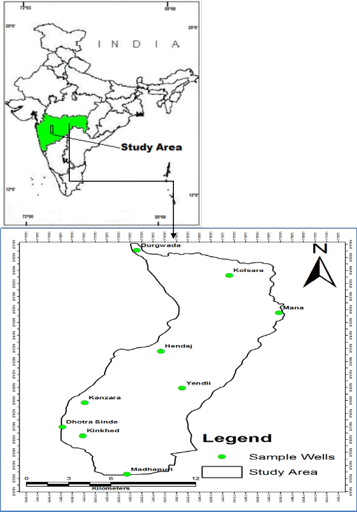
The study area lies in the Survey of India Topographic Sheets No. 55H /6, is bounded
by Latitude of 20°51’ to 20° 51’ and Longitude of 77° 18’ to 77° 32’, (Figure 1) and is located at Akola District. Average annual rainfall is about 900 mm and the mean daily temperatures for the same period range from 40°C in winter to over 46°C in summer. The area of investigation is characterized by the presence of Deccan Trap lava flows with minor occurrence of alluvial zone. Soils in the area are basically derived from basaltic lava flows and alluvial deposits. The soils in the vicinity of part of Purna River are generally deep black to dark brownish grey in colour with calcareous concretions. Land use / Land cover: vegetations and manmade features and omits bare rocks and water. In the study area agriculture is the main land use. Other than the agriculture the area comprises of wasteland, forest land, water bodies and built up.
IJSER © 2013 http://www.ijser.org
International Journal of Scientific & Engineering Research, Volume 4, Issue 9, September-2013 1858
ISSN 2229-5518

The physical characteristic of water contributes to the overall water quality of stream by controlling rates of chemical and biological activities. The effect of temperature, the, electrical conductivity (EC) and Total dissolved solids (TDS) and their impact on water
quality of PTU-1 watershed area is considered.
IJSER © 2013 http://www.ijser.org
International Journal of Scientific & Engineering Research, Volume 4, Issue 9, September-2013 1859
ISSN 2229-5518
Sr. No. | Water Quality Parameters | WHO (1984) Standard accept Max | Max allow limit limit | ISI (1983) Standard Max | Max allow accept limit Limit | Range in study area ( mg/1) |
1. | EC | 1400 | - | - | - | 388 - 2020 |
2. | pH | 6.5 | 8.5 | 6.5 | 9.2 | 06.8 - 08 |
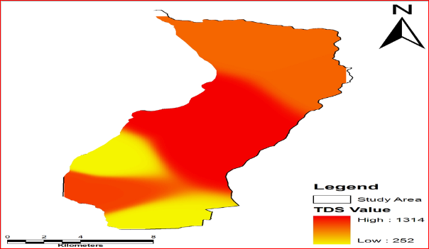
4. | TDS | 500 | 1500 | - | 1500 | 252 - 1314 |
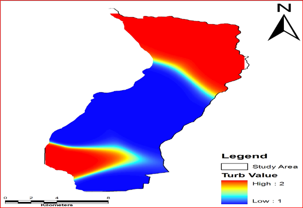
5. | Turb | 75 | 200 | - | 200 | 01 – 02 |
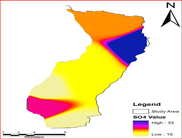
7. | SO4 | - | 200 | - | - | 10 – 33 |
8. | Fluorides | - | - | - | - | 0.9 – 01 |
9.. | Chloride | 200 | 600 | 250 | 1000 | 98 – 1448 |
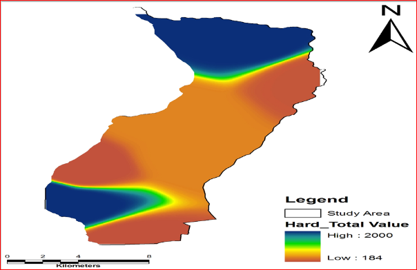
10. | Total Hardness as (CaCO3 ) | 100 | 500 | - | 184 -2000 |
As part of the study, groundwater samples are collected from 8 open and bore wells, of PTU-1 watershed. The samples taken during March 2010 were analyzed for various physico-chemical parameters. Bottles used for water sample collection are first thoroughly washed with the water being sampled and then were filled. After collection of the samples, the samples are preserved and shifted to the laboratory for analysis. Physico-chemical analysis was carried out to determine TDS, TH, Cl, pH, Fe, SO4, TURB and NO3-, and compared with standard values recommended by World Health Organization (WHO, 1993) and Indian Standards Institution (ISI, 1991) (Table 1).
The flow chart in Figure 2 was followed to develop a groundwater quality classification map from thematic maps based on the WHO (1993) and ISI (1991) standards for drinking water. We obtained the location of 8 wells all over the study area by using a handheld GPS instrument GARMIN GPS-60 receiver. GPS technology proved to be very useful for enhancing the spatial accuracy of the data integrated in the GIS. We utilized Arc GIS software in our study. Based on the location data we obtained, we prepared point feature showing the position of 8 wells (Figure 1). From these wells, we collected and analyzed groundwater samples for the study area. The water quality data thus obtained forms the non- spatial database. It is stored in excel format and linked with the spatial data by join option in Arc Map. The spatial and the non-spatial database formed are integrated for the generation of spatial distribution maps of the water quality parameters. For spatial techniques approach in GIS has been used in the present study to delineate the locational distribution of groundwater
pollutants. Other spatial interpolation techniques include Cokriging, Spline etc. Kriging is
IJSER © 2013 http://www.ijser.org
International Journal of Scientific & Engineering Research, Volume 4, Issue 9, September-2013 1860
ISSN 2229-5518
based on the presence of a spatial structure where observations close to each other are more alike than those that are far apart (spatial autocorrelation) (Robinson and Metternicht, 2006; Goovaerts, 1999). In this method the experimental variogram measures the average degree of dissimilarity between unsam- pled values and a nearby data value (Deutsch and Journel,
1998) and thus can depict autocorrelation at various distances. From analysis of the experimental variogram, a suitable model (for example spherical and exponential) is derived by using weighted least squares and the parameters (for example range nugget and sill). Some advantages of this method are the incorporation of variable interdependence and the available error surface output. A disadvantage is that it requires substantially more computing and modeling time and spatial techniques requires more input from the user.
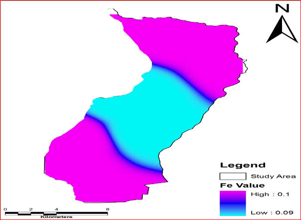
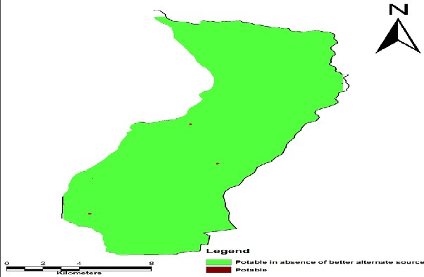
Various physico-chemical parameters like chloride, NO3, TDS, pH, Fe, SO4, TURB and hardness were analyzed in the groundwater samples used for drinking purposes and their levels in different locations of the study area. Table 1 shows a number of major drinking- water quality parameters and their corresponding permissible limits as recommended by WHO (1993) and ISI (1991). Some groundwater samples were found to have chloride, hardness, nitrate and total dissolved solids (TDS) values above desirable limits. We plotted the values for various sample locations and interpolated surfaces. We generated water quality thematic maps for pH chloride, nitrate, Fe, SO4, TDS, and hardness within the study area, showing locations that fell within the potable, potable in the absence of better alternate source and non-potable zones. The entire process of ground water quality mapping can be broadly divided in to three major parts. In the first part, the input data required for generating the ground water quality map is to be processed and to be organized in to a GIS data base. In the second part element-wise ground water quality layers are to be created from the GIS data base. And in the third part, the final ground water quality map is to be derived based on the integration of the element-wise ground water quality layers.
Such thematic maps for the parameters of chloride concentration, TDS and hardness pH, Fe, SO4, were integrated using the addition function available in the Arc GIS software. We created a final drinking-water groundwater quality map by overlaying these various WQ thematic maps which are produced as a result of inverse distance weighted interpolations. The spatial integration for final groundwater quality zone mapping was carried out using Arc GIS Spatial Analyst extension. We then delineated areas within the study area based on the quality of the groundwater for drinking purposes: potable, potable in the absence of better
alternate source and non-potable zone.
IJSER © 2013 http://www.ijser.org
International Journal of Scientific & Engineering Research, Volume 4, Issue 9, September-2013 1861
ISSN 2229-5518
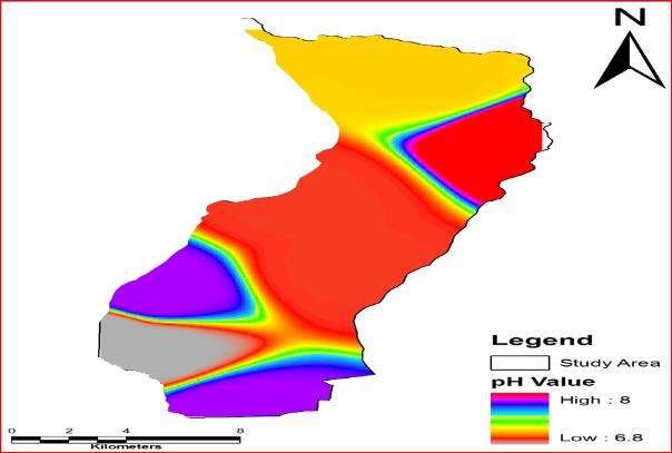
Groundwater quality maps are useful in assessing the usability of the water for different purposes. Figures 2, 3, 4, 5 and 6 show the spatial distribution of electrical conductivity, pH, SO4, chloride, total hardness, total dissolved solids distribution and fluoride concentrations in study area, respectively. A groundwater quality map is created for each parameter following the classification shown in Table 1.
Chloride is minor constituent of the earth’s crust. Rain water contains less than 1 ppm Chloride. Chloride in drinking water originates from natural sources, sewage and industrial effluents, urban runoff containing de-icing salt, and saline intrusion (WHO, 1993). Its concentration in natural water is commonly less than 100mg/L unless the water is brackish or saline (Fetter, 1999). High concentration of chloride gives a salty taste to water and beverages and may cause physiological damages. In the present study Water with high chloride content usually has an unpleasant taste and may be objectionable for some agricultural purposes. The maximum chloride concentration in the study area is 20.1meq/1 which indicates that the groundwater can be grouped as ‘High chloride’ water.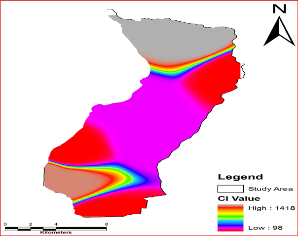
IJSER © 2013 http://www.ijser.org
International Journal of Scientific & Engineering Research, Volume 4, Issue 9, September-2013 1862
ISSN 2229-5518
The pH of the solution can be defined as the negative logarithm to the base 10 of the
hydrogen ion concentration in moles per liter the pH scale has a range from 0 to 14. Neutral water has a pH of 7.0 indicating equal number of H+ and OH- ions; and alkaline water has pH
> 7.0 implying a preponderance of OH ion and acidic water with a pH < 7.0 indicate a dominance of H+ ions. The pH of analyzed sample varies from 6.8 to 8 for pre monsoon of
2010.
The ability of a cube 1 cm. on a side to conduct an electrical current is called electrical conductivity; this is the reciprocal of resistivity and is measured in mhos. Since, mho is too large a unit for fresh water, micromho is used. This is a function of temperature and the kind of ions present and the concentration of other ions. These readings are adjusted
to 250c so that variation in conductivity is a function only of the dissolved ions in water.
Hence, the unit in micromhos/cm at 250c. The range of electrical conductivity (EC) in the study area water sample is 388 to 2020 for pre monsoon of 2010.
No | Village | Lat_Dd | Long_Dd | pH | EC | TDS | Turb | Hardness Total | Fe | Cl | SO4 |
1 | Kinkhed | 20.64 | 77.40 | 6.80 | 1588 | 1032 | 2 | 2000 | 0.1 | 1370 | 19 |
2 | Kolsara | 20.86 | 77.43 | 7.10 | 1329 | 864 | 2 | 1996 | 0.1 | 1418 | 16 |
3 | Madhapuri | 20.69 | 77.59 | 7.70 | 388 | 252 | 1 | 184 | 0.1 | 98 | 10 |
4 | Mana | 20.77 | 77.48 | 8.00 | 1344 | 874 | 2 | 232 | 0.1 | 98 | 33 |
5 | Hendaj | 20.88 | 77.35 | 6.90 | 2020 | 1314 | 1 | 448 | 0.9 | 254 | 14 |
6 | Durgwada | 20.86 | 77.43 | 7.10 | 1329 | 864 | 2 | 1996 | 0.1 | 1418 | 16 |
7 | Yendli | 20.88 | 77.35 | 6.90 | 2020 | 1314 | 1 | 448 | 0.1 | 254 | 14 |
8 | Dhotra Sinde | 20.64 | 77.40 | 6.80 | 1588 | 1032 | 2 | 2000 | 0.1 | 1370 | 19 |
9 | Kanzara | 20.69 | 77.59 | 7.70 | 388 | 252 | 1 | 184 | 0.1 | 98 | 10 |
The mineral constituents dissolved in water constitute dissolved solids. The concentration of dissolved solids in natural water is usually less than 500 mg/L, while water with more than 500 mg/L is undesirable for drinking and many industrial uses. Water with TDS less than 300 mg/L is desirable for dyeing of cloths and the manufacture of plastics, pulp paper, etc. (Durfer and Baker, 1964). The total concentration of dissolved minerals in water is a general indication of the over-all suitability of water for many types of uses. Subba Rao et al. (1998) and Deepali et al. (2001) reported that TDS concentration was high due to
the pre- sence of bicarbonates, carbonates, sulphates, chlo- rides and calcium. TDS can be
IJSER © 2013 http://www.ijser.org
International Journal of Scientific & Engineering Research, Volume 4, Issue 9, September-2013 1863
ISSN 2229-5518
removed by reverse osmosis, electrodialysis, exchange and solar distillation process. It is the concentration of non-volatile substances present in the water in molecular dispersed and colloidal state. Due to surface & subsurface movement of water, it contains a wide variety of dissolved inorganic chemical constituent in various amount. Fundamentally, it is based on concentration of NaCl, which in turn determine the conductivity which has a bearing on TDS.
Conversion between TDS and conductivity in micro siemens or micromho’s/cm. at 250, TDS
in ppm.and varies between 0.55 – 0.75.A value of 0.90 has been arrived at Sawayer and
McCarthy, (1967);Walton, (1970) gave a relation that for groundwater in the range of 100 –
5000 micromoho’s / cm at 250c. in the study area ranges between 252to 1314 for pre monsoon of 2010.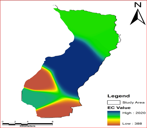
IJSER © 2013 http://www.ijser.org
International Journal of Scientific & Engineering Research, Volume 4, Issue 9, September-2013 1864
ISSN 2229-5518
IJSER © 2013 http://www.ijser.org
International Journal of Scientific & Engineering Research, Volume 4, Issue 9, September-2013 1865
ISSN 2229-5518
IJSER © 2013 http://www.ijser.org
International Journal of Scientific & Engineering Research, Volume 4, Issue 9, September-2013 1866
ISSN 2229-5518
IJSER © 2013 http://www.ijser.org
International Journal of Scientific & Engineering Research, Volume 4, Issue 9, September-2013 1867
ISSN 2229-5518
No | Element | Potable | Non-Potable | |
Desirable limit | Permissible limit | |||
1. | pH | 6.5 to 8.5 | -- | <6.5 to >8.5 |
2. | Total Hardness (as CaCo3) mg/l | < 300 | 300-600 | > 600 |
3. | Iron (as Fe) mg/l | < 0.3 | 0.3-1.0 | > 1.0 |
4. | Chlorides (as Cl) mg/l | < 250 | 250-1000 | > 1000 |
5. | Total Dissolved solids mg/l | < 500 | 500-2000 | > 2000 |
6. | Sulphate (as SO4) mg/l | < 200 | 200-400 | > 400 |
Groundwater is one of earth’s most vital renewable and widely distributed resources as well as an important source of water supply throughout the world. The quality of water is a vital concern for mankind since it is directly linked with human welfare. In India, most of the population is dependent on groundwater as the only source of drinking water supply (NIUA,
2005; Mahmood and Kundu, 2005; Phansalkar et al., 2005). Srinivasamoorthy et al., 2009; Goulding, 2000; Pacheco and Cabrera, 1997). The importance of water quality in human health has recently attracted a great deal of interest. In developing countries like India around
80% of all diseases are directly related to poor drinking water quality and unhygienic conditions (Olajire and Imeokparia, 2001; Prasad, 1984). Groundwater is a valuable natural
resource that is essential for human health, socio-economic development, and functioning of
IJSER © 2013 http://www.ijser.org
International Journal of Scientific & Engineering Research, Volume 4, Issue 9, September-2013 1868
ISSN 2229-5518
ecosystems (Zektser, 2000; Humphreys, 2009; Steube et al., 2009). Considering the above aspects of groundwater contamination and use of GIS in groundwater quality mapping, the present study was undertaken to map the groundwater quality in PTU-1 watershed in the Akola district of Maharashtra, India. This study aims to visualize the spatial variation of certain physico-chemical parameters through GIS. The main objective of the research work is to make a groundwater quality assessment using GIS, based on the available physico- chemical data from 8 locations in PTU-1 watershed in the Akola district of Maharashtra. The purposes of this assessment are (1) to provide an overview of present groundwater quality, (2) to determine spatial distribution of groundwater quality parameters such as Hardness, pH, EC, TDS, Na, and Cl, etc. and (3) to generate groundwater quality zone map for the PTU-1 watershed. The spatial distribution analysis of groundwater quality in the study area indicated that many of the samples collected are not satisfying the drinking water quality standards prescribed by the WHO and ISI. The government needs to make a scientific and feasible planning for identifying an effective groundwater quality management system and for its implementation. Since, in future the groundwater will have the major share of water supply schemes, plans for the protection of groundwater quality is needed. Present status of groundwater necessitates for the continuous monitoring and necessary groundwater quality improvement methodologies implementation.
1. Identification of groundwater recharging locations and structures. For this purpose,
Geographical Information System (GIS) with the required spatial and non-spatial data can be used very well as the tool. Designing recharging structures is to be done.
2. Continuous monitoring of groundwater table level along with quality study will minimize the chances of further deterioration.
Ahn H, Chon H (1999). Assessment of groundwater contamination using geographic information systems. Environ. Geochem. Health, 21: 273-289.
Asadi SS, Vuppala P, Reddy MA (2007). Remote sensing and GIS techniques for evaluation of groundwater quality in Municipal Corporation of Hyderabad (Zone-V), India. Int. J. Environ. Res. Public Health, 4(1): 45–52.
Babiker IS, Mohamed AM, Hiyama T (2007). Assessing groundwater quality using GIS.
Water Resour. Manage., 21(4): 699 –715.
IJSER © 2013 http://www.ijser.org
International Journal of Scientific & Engineering Research, Volume 4, Issue 9, September-2013 1869
ISSN 2229-5518
Barber C, Otto CJ, Bates LE, Taylor KJ (1996). Evaluation of the relationship between land- use changes and groundwater quality in a water-supply catchment, using GIS technology: the Gwelup Wellfield, Western Australia. J. Hydrogeol., 4(1): 6–19.
Burrough PA, McDonnell RA (1998). Creating continuous surfaces from point data. In: Burrough PA, Goodchild MF, McDonnell RA, Switzer P, Worboys M (Eds.). Principles of Geographic Information Systems. Oxford University Press, Oxford, UK.
Burrough PA, McDonnell RA (1998). Principles of Geographical Information Systems
Oxford: Oxford University Press, p. 333.
Butler M, Wallace J, Lowe M (2002). Ground-water quality classification using GIS contouring methods for Cedar Valley, Iron County, Utah. In: Digital mapping techniques, 2002, Workshop Proceedings, US Geological Survey Open-File Report 02-
370.
Davis SN, DeWiest RJ (1966). Hydrogeology, New York: Wiley.
Deepali S, Sapna P, Srivastava VS (2001). Groundwater quality at tribal town; Nandurbar
(Maharashtra). Indian J. Environ. Ecoplan, 5(2): 475-479.
Degaonkar K (2003). Evolving a health caring water supply and sanitation system: public private partnerships in developing economy. Proceedings of third international conference on environment and health, Chennai, India, 15-17 Dec.
Ducci D (1999). GIS techniques for mapping groundwater contamination risk. Natural
Hazards, 20: 279-294.
Durfer CN, Baker F (1964). Public water supplies of the 10 larger city in the U.S. Raju, K.C.B., Rao, G.V.K. and Kumar, B.J. (1985). Analytical Aspects of remote sensing techniques for ground water prospecting in hard rocks. Proc. Sixth Asian Conference on remote sensing, pp.127-132.
Deutsch CV, Journel AG (1998). GSLIB: Geostatistical Software Library and User’s Guide.
Oxford University Press, Oxford, UK.
Engel BA, Navulur KCS (1999). The role of geographical information systems in groundwater engineering. In: Delleur JW (ed) The handbook of groundwater engineering. CRC, Boca Raton, pp. 703–718.
Geological Survey. Water Supply, 1812: 364.
Groundwater quality mapping using geographic information system (GIS): A case study of
Gulbarga City, Karnataka, India,
P. Balakrishnan1*, Abdul Saleem2 and N. D. Mallikarjun2 in ISSN 1996-0786 ©2011
Academic Journals.
IJSER © 2013 http://www.ijser.org