International Journal of Scientific & Engineering Research, Volume 4, Issue 6, June-2013 1878
ISSN 2229-5518
1.Department of Geology, Sant Gadge Baba Amravati University, Amravati-444602 (MS)
2. Groundwater Survey and Development Agency, Chandrapur (MS) Email: syedkhadri_62@yahoo.com
The Vidrupa river area is a part of the Purna alluvium basin. In this area various geological formations are well exposed. In regional set up of the study area presence of a small
patch of sandstone belonging from Gondwana formation exposed at near Pimparkhed village of
Telhara taluka. The length of sandstone is about 1.5 to 2.00 km and 100 to 200 m in width
observed in between Bazada zone and Purna alluvium towards the Northern part of the study area. In the study area, the detailed flow by flow field mapping and correlation of the extent of lava flows in the field by differentiation them with the help of distinct field characters along with petrographic observations and computer aided statistical techniques have led to the establishment of a comprehensive field stratigraphy of the Vidrupa region. Based on field and petrographic investigation coupled with geological mapping as well as the Vidrupa River basin can be subdivided into 2 well defined formations namely Chippi and Dhondakhar comprising of 10 different lava flows. The results of this study have established the flow by flow field stratigraphy of the Vidrupa Volcanics based on field mapping of individual lava flows and petrographic correlation of various lava flows. In this study an attempt has been made to decipher the petrogenetic significance of the lava pile and the aerial extent of the individual lava flows. In addition, in this study an attempt has been made to correlate the lava flows not only in the study area but also in the adjoining regions so as to establish the field stratigraphic sequence.
Key Words: Field Mapping, Field Stratigraphy, Lava Flows, Flow Correlation, Petrogenesis
Field studies are the main method of obtaining geological data. Field studies should have a purpose, even if it be strictly academic. The study may be as simple as a single outcrop
of interest or an open pit quarry. These simple studies may include a sketch, some digital photos, GPS coordinates, making notes on relations between rocks, and or collecting some
hand samples. Other field studies may be complex requiring extensive time in the field utilizing systematic sampling methods of rocks, soil, and even water with detailed mapping in computer
applications. Geologic mapping is the backbone of the field study and is frequently referred to as field geology. Mapping finds relations between rocks and other geologic interests. Despite our
advanced technology many geologic features of importance such as folds and faults can only be found by geologists with their boots on the ground, in the field, mapping an area. Some ore
deposits may be found with airborne geophysics but in reality, few are, it is the geologist in the field that makes the discovery. Ultimately, maps convey more than words ever will. Mapping
comes down to the observations at the individual outcrops as being the fundamental principle of field geology. The observation and an interpretation is made, a hypothesis is developed, and
tested by any means available. The individual outcrop will be the most rudimentary aspect of mapping. As the map develops complex relations are revealed.
IJSER © 2013 http://www.ijser.org
International Journal of Scientific & Engineering Research, Volume 4, Issue 6, June-2013 1879
ISSN 2229-5518
.
The flow stratigraphy of Deccan Traps is still unknown over a large region or at least
poorly known. The correlation of various lava flows in the field between separate stratigraphic sections of tholeiitic basalts is extremely difficult at many places due to the change in flow character over relatively short distances often coupled with late tertiary erosion. Radiometric dating could be used to elucidate stratigraphic relationship but because nearly all Deccan Traps are Fine grained, tholeiitic basalts, such work has been limited to K-Ar method (Wellman and McElhinny, 1970; Kaneoka and Haramludra, 1973). Two very young but not widely accepted K- Ar dates have been reported by Alexander (1981) one in the south-west Deccan (31 Ma) and another in a western outlier of the Malwa plateau (37Ma). Recent studies by Duncan and Pyle (1988) have indicated a time span of 65 to 69 Ma for Deccan Traps.
Recent investigations by various research groups on Deccan Traps (Cox and
Hawkesworth, 1984, 1985; Bodas et. al.. 1985; Beane et.al., 1986; Devey and Lightfoot, 1986; Subbarao et. al., 1994 and Khadri et. al.. 1988.1996). Based on field, geochemical, Petrographic and Palaeomagnetic investigations, a comprehensive stratigraphy for both Western Deccan Basalt Province and Malwa Trap have been established. The Western Deccan Basalt Group embraces 12 well defined formations (Table 4.1) which fall into three subgroups (Kalsubai, Lonavala and Wai). The northern part of the Western Ghat expose the oldest part of the lave pile (Kalsubai subgroup) while the younger subgroups were exposed towards south. The Kalsubai subgroup includes 5 formations namely Jawahar (oldest), Igatpuri, Neral, Thakurvadi and Bhimashankar (youngest). The Lonavala subgroup is divided into Khandala and Buishe formations whereas the Wai subgroup is made up of Poladpur. Ambenali, Mahabaleshwar, Panhala and Desur formations (Beane et. al., 1983, 1986, Cox and Hawksworth, 1984; Lightfoot,
1985; Beane, 1988; Khadri et. al., 1989) In the Malwa region very limited work has been done to
establish the flow stratigraphy (Srinivasarao et. al., (1985) and Dhandapani and Subbarao, (1992) have divided 650 m thick lava sequence of Malwa trap into four formations namely Narmada, Manpur. Mhow and Satpura.) However, Khadri et, al., (1996) have made an attempt to correlate the Malwa Traps from the Mograba-Buhmandaw region with the Western Ghat stratigraphy in order to identify the relative stratigraphic sequence. Considering the vastness of the area and magnitude of the problem, a sincere attempt has been made in this study to establish the stratigraphy of Khongda Volcanics and to correlate them with the Western Ghats with special reference to east Pune basalts. It is hoped that these results may provide a model to bring out the regional evolution and structure of Deccan Traps as a whole.
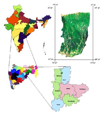
The study area is located at Telhara and Akot Taluka of Akola district of Maharashtra
which is covered under the Survey of India toposheet no 55C/16 and D/13. The study area is covered by Purna Alluvium and is located at about 145 km from Amravati and about 75 km from Akola between. 20° 54' 30” to 21° 14' 35" N latitudes and between 76° 48' to and 770 03’E longitudes (Fig. 1). The published data on, southern and eastern site of the study area has also been utilized for obtaining a comprehensive stratigraphy and petrogenetic history of the Deccan Trap flows, in addition to the data obtained through the present study. The river originate in the foot hills of Satpuda hill ranges situated towards the North of Akola district, the course of river passing near the Dhondakhar and Chippi a tribal village and flowing through across narrow
gauge railway tract and near Adgaon budruk village. The major path of river course is almost in a straight line towards the Purna basin.
IJSER © 2013 http://www.ijser.org
International Journal of Scientific & Engineering Research, Volume 4, Issue 6, June-2013 1880
ISSN 2229-5518

The Vidrupa river area is a part of the Purna alluvium basin. In this area various
geological formations are well exposed. In regional set up of the study area presence of a small patch of sandstone belonging from Gondwana formation exposed at near Pimparkhed village of Telhara taluka. The length of sandstone is about 1.5 to 2.00 km and 100 to 200 m in width observed in between Bazada zone and Purna alluvium towards the Northern part of the study area (Fig 2).
Deccan Traps are exposed completely Northern most part of the study area at the foothills of Satpuda ranges of Akot and Telhara taluka. The different types of lava flow have been
recognized in the study area, are thick tabular having large areal extent. They are the ‘pahochoe’ (compound) and ‘aa’ (simple) or blocky lava.(Rajarao et.al.,1976) The ‘pahochoe’, which is very
mobile in nature with smooth and glazed surface showing rope like wrinkles. The flow can also be classified as vesicular and compact massive. The vesicles may be of different shape and size
filled with secondary mineral like variety of silica, calcite and zeolites. However, the study area is mostly dominated by compound flow of vesicular, amygdaloidal and massive in nature. The
vesicular flow are well exposed at traverse no 1 near the village Bhilli.(Plate 2.1A). More than
IJSER © 2013 http://www.ijser.org
International Journal of Scientific & Engineering Research, Volume 4, Issue 6, June-2013 1881
ISSN 2229-5518
one smaller flow unit with limited aerial extent can be observed in the compound flow. Compound flows show a shield like form and are though to develop when the rate of extrusion of lava is relatively slow.(Walkar,1972).The sticking variation not only in the phynocryst contain between one flow unite and the another also between top and bottom of the same unit is the characteristic feature of the flow. The flow unites are characterized by the presence of pipe amygdule or spiracles at the base and ropy vesicular tops. The thickness of the compound flow varies to large extent with large aerial extent. Vesicles showing spherical or elliptical shape with smooth or irregular outline are generally abundant compound flows. The visible flow contact in between simple flow and compound flow was recognized in field near the village Dhondakhar.
.(Plate 2.1B). However the thin flows are vesicular throughout and vesicles are more abundant in
the central part (Khadri, 1989). During the study in field reorganization of 10 different flows of compound and simple flows are identified on the basis of variation in grain size, mineral assemblage and petrographic studies.
In general the major part of the study area occupied by alluvium which is belonging
from the Purna alluvium. Purna alluvium filled in valley basin extends East-West for a stretch of 170 km having maximum width of 55 km The valley is bounded in the North of Satpuda hill ranges , the total area covered is 7500 sq. km out of which, 2827.13 sq km is characterized by saline water or brackish water . This saline zone is extending Amravati, Akola and Buldana dist. Wynne (1869) first described geology and structures of Purna valley. Fox (1914) investigate the problem of water supply of Akola dist. and recommended extraction of groundwater for sweet water pockets. Crookshank (1926) also investigated alluvial deposit and describe lithology. Shri A.K. Roy (1949) surveyed these alluvial formation and studies detailed aquifer characteristics of different formation. Kailasam (1949) and Mathew (1950) carried out the geophysical survey of Purna valley and identified sweet and saline water aquifer. The thick deposits of alluvium sediments comprising of clay, silt, sand and gravel are found in Purna river valley in the Northern part of the study area. The Purna alluvium attains a thickness of 450 m as deciphered in the exploratory bore well of CGWB. The alluvium can be divided into younger and older alluvium. The younger alluvium which is 70 to 80 m thick includes sub angular to sub rounded basaltic gravel. The older alluvium is more than 250 to
300 m and mainly consists of reddish yellow clay (Table 1).
The major part of the study area is covered by the Purna alluvium, the sand layer and gravel beds have high capacity of porosity and permeability. In the Purna alluvium, it is the major water bearing formation as it is found in patches along river course. In the study area, the alluvial zone may be divided into fresh ground water belt in the North and saline area in the South. The fresh water in the North can be divided into two zones consisting of Northern zone which is occupied by soft weathered boulders of basaltic formation (Bazada zone) covering an area of 1500 sq km having a width of 10 km and a length of 130 km., where as the saline area in the South covers about 3000 sq km consisting of Amravati, Akola and Buldana district.
IJSER © 2013 http://www.ijser.org
International Journal of Scientific & Engineering Research, Volume 4, Issue 6, June-2013 1882
ISSN 2229-5518
![]()
![]()
Recent Black Cotton soil Thick Layer of
Local Alluvium Black Cotton Soil
--------------------------------Angular Unconformity -------------------------- Quaternary Alluvium Yellow colour clay,
With sand bed and
Silt with course sand,
gravel, and Boulder
------------------------------- Unconformity --------------------------------
Upper cretaceous Deccan trap Basaltic Flow to lower Eocene
------------------------------- Unconformity -------------------------------- Middle cretaceous Gondwana Sand Stone
to Permian![]()
During the field study of Vidrupa river basin, an attempt has been made to identify the nature, distribution, thickness of alluvium and horizontal flows of basalt by observing the field
characters, different in textural feature, variation in grain size, the presence of red/green boles occurring at flow boundaries and weathering pattern along with nature of jointing are also taken
into consideration while studying the various flow. While carrying the field study four (4) field traverse were measured during four field seasons with sufficient cross check which indicates the
presence of ten lava flow within the study area.
In general the lava flow can be classified into Plagioclase Phyric Flow, Phyric Basalt with
minute plagioclase Flows, Aphyric basalt with minute glassy Flow, Aphyric amygdaloidal basalt flow, Aphyric Amygdaloidal Flow, Microphyric plagioclase with vesicles Flows and Porphyritic Phyric plagioclase with GPB. (Fig. 3)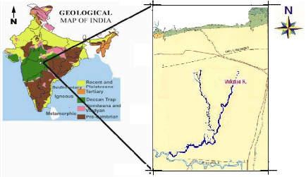
IJSER © 2013 http://www.ijser.org
International Journal of Scientific & Engineering Research, Volume 4, Issue 6, June-2013 1883
ISSN 2229-5518
For the identification of individual flows of closely related flow sequences as well as for grouping them in recognizable stratigraphic units with the help of extensive field, petrographic
and geochemical data, the following nomenclature is adopted in the study area. The principal lithostratigraphic units adopted in this study includes Group, Subgroup, Formation, Member and
Bed (flow), which are in accordance with the classification of international sub commission on the Stratigraphic terminology. However, for better understanding, each formation is divided into
lower, middle and upper divisions (wherever possible) comprising of various chemical types
(CT). The conventional hierarchies of formal litho-stratigraphic terms are as follows.
differentiated assemblage of formations (i.e. Kalsubai, Lonavala Subgroups).
a unit layer in the stratified sequence of basalts, which is lithologically distinguishable from the layer above and below. A flow can be either compound or simple. Each compound flow is characterized by the presence of numerous flow units. The base of the flow unit in many cases is indicated by the presence of pipe amygdales and top of a flow unit often exhibits a ropy structure (Walker, 1972). Simple flows are characterized by the absence of flow units with more uniform nature and show development of flow top breccias. In same places the thickness of a flow varies from a few meters to more than 100 m, where litho logic identity is difficult because of poor or lack of exposures. The unit may be identified and correlated on the basis of certain criteria like geomorphic expression, Lithology and distinctive vegetation etc. Which are only indirect evidences of lithology.
Chemical Type: One or more members within a formation having similar chemical parameters without a stratigraphic bias are known as chemical type (CT). TiO2, MgO, CaO, P2O5, Cr, Ni, Zr, Y, Ba /Y, Ba/Ti, Ba/Zr, TiO2/P2O5, Ba/Sr. Zr/Y. Sr/Y and Mg* can be used as useful
IJSER © 2013 http://www.ijser.org
International Journal of Scientific & Engineering Research, Volume 4, Issue 6, June-2013 1884
ISSN 2229-5518
chemical parameters in identifying a chemical type. Chemical types (CT) may be repeated at different stratigraphic levels. Each CT exhibits a lesser range of variation within it than between other CTs (Reidel, 1983). However, in certain cases a few samples show abnormal chemical range, which makes the definition of CT less rigid. These samples show considerable overlap with the neighboring CTs, which makes the total variation fairly continuous one.Five different chemical types showing significant variations in geochemical signatures have been identified in the study area. They include.
CT1: Fine grained, aphyric, minutely amygdaloidal flow.
CT2: Medium grained mafic phyric to picritic basalt. CT3: Plagioclase + mafic phyric flow.
CT4: Medium grained, plagioclase phyric flow.
CT5: Coarse grained, highly evolved. Giant Plagioclase Basalt.
The ability to distinguish various flows and trace them in different field sections on a
regional scale is an important criterion in the stratigraphic investigations. In order to have a better control in this aspect, an ideal composite section with maximum thickness can be selected as a type section and all other adjacent sections have to be compared and correlated with it. The type section represents an authentic sequence of the strata, which serves as an objective standard and exhibits maximum development of lithostratigraphic units. In order to maintain the uniformity in nomenclature, the names given by Sreenivasa Rao et. al., (1986), Beane et. al., (1986) and Khadri et. al., (1988, 1996) have been retained in this study. Stratigraphic marker horizons are particularly useful for the stratigraphic purposes. Marker horizons are characterized by certain factors such as lateral tractability, physiographic expression and lithological homogeny.
The ability to distinguish various lava flows and trace them in different field sections on
regional scale is an important criterion in the present stratigraphy investigation. Based on field
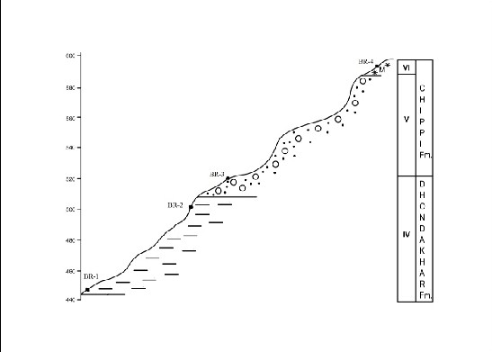
and petrographic investigation coupled with geological mapping as well as chemical variation, Detailed geological mapping of the lava flows based on 4 field traverses coupled with petro graphic and geochemical investigations have led to the identification of 350 m thick lava pile into two formations viz., ’Dhondakhar’ Formation and ’Chippi’ Formation, comprising of 10 lava flows
In the study area, the ‘Dhondakhar’ Formation is well exposed near village Dhondakhar, Jitapur and Pimpri khurd. In Jainpur pimpri field traverse the lava flows are exposed with a
thickness of about 150 meters. This Formation consists of five flows, which are characterized by the presence of fine to medium grained mafic plagioclase microphyric flow. The results of
petrographic and geochemical studies confirm the proposed field stratigraphy.
The Chippi Formation is well exposed near Diwanzari and Borvha villages. In Diwanzari field traverse with a thickness of about 100 meters. This Formation consists of four flows, which
are characterized by the presence of fine to medium grained mafic plagioclase microphyric flow. Borvha field traverse with a thickness of about 140 meters. This Formation consists of three
flows, which are characterized by the presence of fine to medium grained mafic plagioclase microphyric flow. The results of petrographic and geochemical studies confirm the proposed
field stratigraphy.
IJSER © 2013 http://www.ijser.org
International Journal of Scientific & Engineering Research, Volume 4, Issue 6, June-2013 1885
ISSN 2229-5518
Jainpur Pimpri traverse is on the North East side of the study area, having maximum
elevation of this traverse is 370m and minimum elevation is 300m. In this traverse two flow belonging to Dhondakhar formation showing fine to medium grain aphyric, amygdoidal basalt with mafic microphynocryst. The Jainpur Pimpri village is located towards East direction of the traverse (Fig.3).
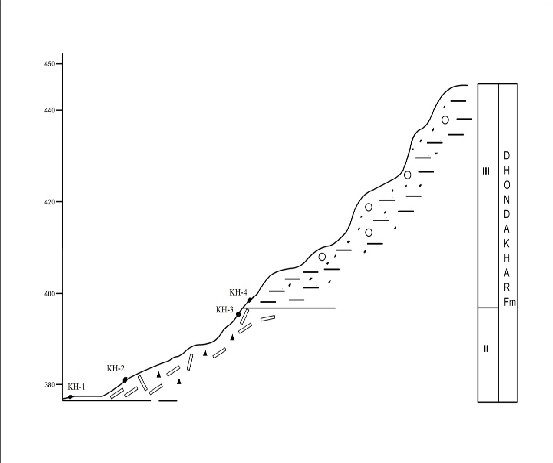
This traverse is Northern part of the study area and attaining the maximum elevation is
about 450 m and minimum elevation is 380 m. This traverse is characterized by presence of two different basaltic flows which is medium to coarse grained mafic plagioclase phyric to microphyric and aphyric amygdoidal basalt. The village Chippi and Dhondakhar is known as a tribal villages located towards the west of the traverse (Fig. 4).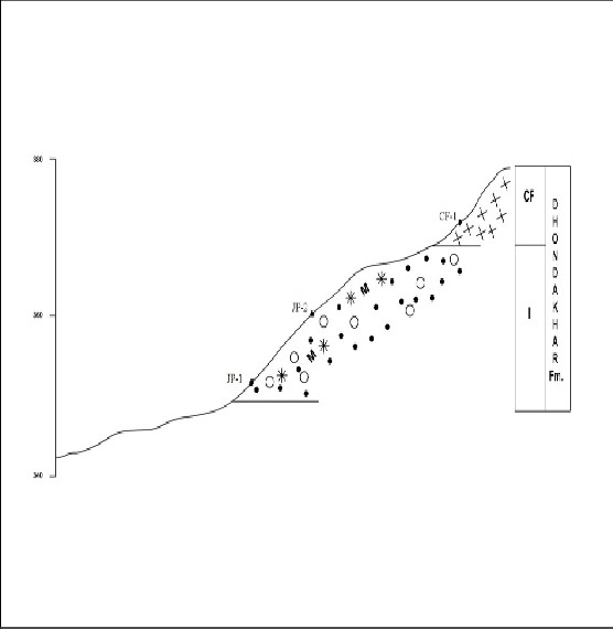
IJSER © 2013 http://www.ijser.org
International Journal of Scientific & Engineering Research, Volume 4, Issue 6, June-2013 1886
ISSN 2229-5518
This traverse is North West part of the study area and attaining the maximum elevation is about 600 m and minimum elevation is 460 m. This traverse is characterized by presence of three different basaltic flows. This is fine to medium grained micro phyric mafic and medium to coarse grain aphyric with highly amygdaloidal basalt with zeolitic horizon. In this traverse the village Bhilli is also known as a tribal and remote village located towards the west of the traverse Divanzari Traverse:-
This traverse is uppermost Northern part of the study area and attaining the maximum elevation is about 710 m and minimum elevation is 620 m. This traverse is belongs to Chippi
formation. This traverse is characterized by presence of three different basaltic flows. This is fine to medium grained phyric to aphyric with minute mafic microphynocryst and minute glassy
patches with phyric basalt. This traverse is a part of Satpuda hill ranges.
IJSER © 2013 http://www.ijser.org
International Journal of Scientific & Engineering Research, Volume 4, Issue 6, June-2013 1887
ISSN 2229-5518

IJSER © 2013 http://www.ijser.org
International Journal of Scientific & Engineering Research, Volume 4, Issue 6, June-2013 1888
ISSN 2229-5518
In this study an attempt has been made to understand the preliminary field stratigraphy of
the Vidrupa River basin which can be subdivided into 2 well defined formations namely Chippi and Dhondakhar comprising of 10 different lava flows. In the study area, The detailed, petrographic, mineralogical, investigations along with computer aided statistical techniques have led to the establishment of a comprehensive flow stratigraphy of the Vidrupa region. Dhondakhar’ Formation is well exposed near village Dhondakhar, Jitapur and Pimpri khurd. In Jainpur pimpri field traverse with a thickness of about 150 meters. This Formation consists of five flows, which are characterized by the presence of fine to medium grained mafic plagioclase microphyric flow. The results of petrographic and geochemical studies confirm the proposed field stratigraphy. Chippi Formation is well exposed near Diwanzari and Borvha villages. In Diwanzari field traverse with a thickness of about 100 meters. This Formation consists of four flows, which are characterized by the presence of fine to medium grained mafic plagioclase microphyric flow. Borvha field traverse with a thickness of about 140 meters. This Formation consists of three flows, which are characterized by the presence of fine to medium grained mafic plagioclase microphyric flow.
In this study an attempt has been made to decipher the petrogenetic significance of the lava pile and the aerial extent of the individual lava flows. In addition, in this study an attempt has been made to correlate the lava flows not only in the study area but also in the adjoining regions so as to establish the field stratigraphic sequence. The results of petrographic and geochemical studies confirm the proposed field stratigraphy. The results of this study have established the flow by flow stratigraphy of the Vidrupa Volcanics based on field mapping of individual lava flows and petrographic correlation of various lava flows. In this study an attempt has been made to decipher the petrogenetic significance of the lava pile
Beane, J.E , Turner, C.A., Hooper, P.R,, Subbarao, K.V., Walsh, J.N, and Beckinsale, R.D.,
1983. A priliminary stratigraphy of basalt flows in part of the Western Ghat, Deccan, India,
IAVCEI, Hembi; Irg meeting abstracts, p.92.
Beane, J.E., Hooper P.R,, and Subbarao, K.V., 1988. Petrogenesis of the Kalsubai and Lonawala
Sub-groups, Deccan Basalt Group,India. International Conference Geochemical Evolution of the Continental Crust, Docos decaldas, Brazil (Abstracts), pp. 48-53.
Beane, J.E., Turner, C.A., Hooper, F.R., Subbarao, K.V. and Walsh, J.N., 1986. Stratigraphy, Composition and form of the Deccan Basalts, Western Ghats, India. Bull. Volcano!., vol :
48, pp. 61-83 Beane, J.E., 1988. Flow stratigraphy, Chemical variation and Petrogenesis of the Kalsubai and Lonwala Sub-groups, Deccan Flood Basalts from the Western
Ghats.India. Ph.D. thesis (Unpublished), Washington State University, USA.
Bodas M.S., Khadri S.F.R., Subbarao K.V., Hooper P.R., and Waish J.N. (1985) I'roc. ladian
Govt. Congr., V. Session, Bombay, pp. 339-346.
Bodas M.S., Khadri S.F.R., and Subbarao K.V. (1988) "Stratigraphy of the Jawhar and igatpuri
formation, western ghat lava Pile." Memoir No.10, Jr.Geol. Soc.India, pp.235-253.
Courtil lot, V., Feraud, G., Vendamme, D., Maluski, H. Moreau, M.G. and Besse, J. J., 1988
Deccan flood basalts and the Cretaceous/tertiary boundary. Nature,Vol :333,pp. 843-844. Cox, K.G and Hawkesworth, C.J. 1983, Relative contribution of crust and mantle to flood-basalts
magnetism in the Deccan Traps. (Abstract). A meeting for discussion of the relative
IJSER © 2013 http://www.ijser.org
International Journal of Scientific & Engineering Research, Volume 4, Issue 6, June-2013 1889
ISSN 2229-5518
contributions of mantle, oceanic crust and continental crust to magma genesis. Royal
Society of London.
Cox, K.G, 1983. The Karoo Province of South Africa; Origin of trace element enrichment patterns. In: Hawkesworth. C.J., and Norry, M.J., (Eds.)Continental basalts and mental XeLloliths. Shiva Pub. Ltd., London., pp. 139-157.
Cox, K.G. and Clifford, P., 1982. Correlation coefficient patterns and their interpretation in three
basaltic suits, contrib. Mineral. Petrol., Vol. 79, pp. 268-278.
Cox, K.G. and Hawkesworth, C.J., 1984. Relative contributions of crust and mantle to Flood
Basalt Volcanism, Mahabaleshwar area, Deccan Traps. Phil. Trans.R. Soc. Lond. Vol : A310, pp. 627-641,
Cox, K.G. and Hawkesworth, C.J., 1985. Geolchemical stratigraphy of the Deccan trapsat
Mahabaleshwar area. Western Ghats, India, with implications for open system magnetic
processes. Jour. Petrol., Vol : 26, pp.355-377.
Cox, K.G., 1972. Karoo lava and associated igneous rocks of Southern Africa.Bull Volcan.. Vol :
35, pp. 867-886.
Crawford, A.R., 1978. Narmada-son Lineament of India traced into Madagaskar. Jour. Geol.
Soc. India,, Vol : 19, pp.144-153,
Crookshank, H., 1936. Geology of the northern slopes of the Satpura between the Morand and
Sher Rivers. Mem. Geo). Surv. Ind,,Vol : 66, pt. 2.
Devey C.W. and Lightfoot P.C. (1986) Volcanolo^ical and tectonic Control of stratigraphy and
structure in the western Deccan traps." Bull. Volcanol. Vol.48, pp.195-207.
Khadri S.i-'.K., Subbarao K.V. and Uodas M.S. (1988) (a) "Magnetic studios in a thick pile of
Deccan trap flows at Kalsubai." Memoir No.lU, Jour.Geol Soc., Ind., pp.163-180.
Khadri S.F.R., Subbarao K.V., Hooper P.K. ?nd Walsh j.N. (1988) "Stratigraphy or thakuradi
formation, western Deccan Basalt provence." Ind., memoir, No.10.Jr.Geol. Soc. India, pp.281-304.
Sreenivasa Rao M., 1984. Flow stratigraphy and palaeomagnetison of khalghat flow volcanics, Narmada region, Deccan volcanic province. Ph.D. Thesis (Unpublished). ITL, Bombay.
264 P.
Sreenivasa Rao M., Ramasubba Reddy N., Subbarao K. V., Prasad C. V. R. K. and
Radhakrishnamurty C., 1985. Chemical and magnetic stratigraphy of parts of Narmada region, Deccan basalt province; Jour. of Geol. Soc. Ind., Vol. 26., PP. 617-639.
Thompson, R. N., 1977. Primary basalts and magma genesis III : Alban Hills, Roman
Comagmatic Province, Central Italy - Contrib. Mineral. Petrol. PP. 91 -108.
IJSER © 2013 http://www.ijser.org