International Journal of Scientific & Engineering Research, Volume 4, Issue 11, November-2013 948
ISSN 2229-5518
DIGITIZED PROFILE OF LAND FOR AGRICULTURE USE IN PUNJAB, PAKISTAN
S. M. Mehdi1, M. Ramzan1, A. Ashraf2, U. A. Ali1, Z. A. Ali1, A. A. Sheikh, M. N. Kamal1
1. Soil Fertility Research Institute Punjab, Lahore, Pakistan
2. GIS Centre, Punjab University College of Information technology, Lahore, Pakistan
ABSTRACT
Agriculture has a significant role in the development of this world trade economy in historical perspective. Now, for the betterment of foodstuff security and foreign debt strategies, observing the assumptions behind the production of national agriculture in countries like Pakistan seek attention. We need to maintain that all these assumptions have definite deficiencies between theories and real obstacles. In scope, the relationship between Industry and agriculture has been more fluid and global. For those countries whose economy directly depends on agriculture it is essential for them to get precision in this field. Geographical Information System provides the set of tools to handle the upcoming issues related in this world. On the bases of GIS technologies we can identify about the precise quantity of how much seed to buy, where to plant and how much compost of fertilizer to use. SFRI took a bold step in this trail and became the pioneer in the agriculture of Pakistan to develop this type of automated system under the project entitled “Development of Digitized Profile of Land for Agriculture in the Punjab Province’’. This research produces a mechanism for intelligence system to create an automatic area exploration, visualization of maps, crop suitability and fertilizer recommendation on the basis of analyzed soil components (EC, pH, OM, N, P, K, Texture) and water component (EC, SAR, RSC).
Key words Digitized profile, Land, Agriculture, Crop suitably, Fertilizer recommendation
INTRODUCTION

Land is a basic unit, which is used to perform human activities like forestry, horticulture and agriculture. From earliest times, in New Zealand settlers have used the land to produce food and fiber like wool and flax to build abode and raise animals. Today, New Zealanders assess their land for its scenic, cultural, recreational and chronological significance [1]. In the biotic ecological meaning land is the source of global bio-diversity by specifying biological territory and genetic material for vegetation, flora and fauna and micro-organisms, above and below Land [2].
Relating to water a healthy soil can perform a number of vital functions like store water and nutrients, helps to regulate water flow, and neutralize all kinds of pollutants [3]. Soil production capacity is limited and these limits are laid down by intrinsic characteristics, agro-ecological settings, apply and management [4].
Being an agricultural country, Pakistan has a natural ability to produced a large range of agricultural product to fulfill in home requirements and moreover able to export. Its 21.2 % of GDP depends on agriculture, and about 25% of land is arable having one of the largest irrigation systems of world [5].
Planning and development are essential for an agricultural land. Agriculture was a major source of income for domestic industry in the United States. It was the source of nation building of US on the basis of
development theories came from late nineteenth century to the end of World War II. US became a model for post-war remedies by using national inter- sectoral stability schemes and its agriculture products were export-oriented. The American model generalized to gain money with the rise of America [6].
Historically, mainly the enlargement of the various civilizations flourished in the Middle East was dictating by the accessibility of fertile soil and water. Continuous cropping was only feasible where the soils were rich in nutrients or fertility was regenerated through flood-borne sediments. While these days the main constraint to grow crops is inadequate moisture, due to limited water supplies and erratic rainfall, economic crop production is not feasible without an adequate supply of the fundamental nutrients, either from the soil or added as fertilizers. During the past three four decades, when chemical fertilizers began to be used extensively, has established the essential need of fertilizer nitrogen N in all regions specially in drought stressed areas. Likely, the calcareous nature of most soils in the region such that phosphorus P fertility is low, and thus without added P fertilizer sufficient crop yields are not possible. Fortunately, other important crop growth nutrients such as potassium, magnesium, calcium, and sulfur are well supplied in less fertile soils. While mostly work reported comes from countries of the region of Syria,
IJSER © 2013 http://www.ijser.org
International Journal of Scientific & Engineering Research, Volume 4, Issue 11, November-2013 949
ISSN 2229-5518
Morocco, and Lebanon from collaboration with scientists in other countries of the Middle East region like Libya, Algeria, Iraq, Tunisia, Turkey, Iran, Jordan, Cyprus and Spain through various research networks [7].
These agricultural problems have crippled the economy of Punjab. Other countries like the USA, Canada, China, Germany, India and Russia have shown significant enhancement in their agriculture sector, but Pakistan is unable to match the pace of development. Main agriculture problems in Punjab are Irrigation issues, Water settlements, Absence of Land Reforms, Inconsistent government policies, Lack of accountability, Infrastructural problems, Lack of Research and Development and negligence of education and training of farmers for their field. It does not matter how long lived and deep rooted are the problems of agriculture in Punjab, they can be easily solved with due deliberation in to them.
Soil is the significant important natural resource of any country which makes the country prosper and boost its power of food production. Pakistan contains several types of soils, which can be divided into significant varieties. This encourages adopting different approaches to empower and sustainably use this resource. Pakistan depends on existing soil resources. To use optimally this resource it is the need of hour to protect agriculture land from other uses that may result in its degradation or loss in yield. By the increase of agriculture productivity not only increase in food but also increase the fiber and shelter moreover improve the environment. Various departments contain several types of agriculture based statistical and realistic data but issue is that they have no rules and regulations to share these types of data for the flare of farmer and researcher. To overcome this issue it is the dead need for the think tanks to develop such kinds of system, which are totally automated and easily accessible for the stakeholders even the layman or farmer.
In Agriculture, fundamental task is to manage inputs and outputs in the arable farm to achieve the desire yield and profitability. For this purpose, GIS work- flows have proven to be efficient and beneficial for all stakeholders of farming industry [8]. GIS has magnificent ability to manage, analyze and visualize agriculture environments. Natural inputs and outputs in agricultural cannot be proscribed, they can be improved, validated and managed using GIS tools and techniques such as crop yield assessment, soil adjustment analysis, attrition detection and remediation [9].
GIS enabled Management Information System is
described as the system which offers spatial and attributes management using formalized trail. This system provides useful functions along with suitable information, retrieved from multiple internal and external data source to get appropriate, precise and effective results. It is not necessary to have prior computer competencies. Information system designed for agriculture provides ease of access to the information in a productive way at various stages of agriculture research life cycle containing major processes are Identify problems, set priorities, planning, financing, reporting and implementation. Purpose of this cycle is to produce standard analytical and graphical reports for further decision making [10].
In this paper focus is on Punjab province, which is a food basket for Pakistan. Economic yields can only be achieved if crops are grown in the environment that is optimum for specific plants. Improving understanding and awareness level about particular soil, water and environmental conditions can be of great help to improve crop production. This idea can be easily achieved by using recent GIS innovations and by making information public. It is imperative that through use of GIS in agriculture as a tool for spatial data integrated with actual soil and Water data to display soil fertility maps that are informative for progressive farmers, planners, policy makers, researchers, landowners & extension workers.
Directorate of soil fertility Research Institute Punjab, Lahore took a bold step in this trail and became the pioneer in Pakistan to develop this type of automated system and launched a project entitle “Development of Digitized Profile of Land for Agriculture in the Punjab Province ". This project has excellence to accomplish the need of data sharing and visualization using GIS techniques to assist agriculture and related research. This project centralizes the data in the form of well structured database using high proficiency market software and hardware. Agriculture department is compiling all available resources in development of authenticated and reliable database. By the mean of this project development of Web-GIS application has arranged, an intelligent system to identify gap between actual and potential crop yield has produced and a mechanism to create an automatic recommendation for controllable factors has also developed.
2 BASIS OF AGRICULTURAL WEB-GIS SYSTEM
2.1 Existing Web-GIS System
United States Department of Agriculture is producing huge amount of agricultural data which contains geospatial information from last three to four decades. In order to make this data authorized, USDA has developed large number of GIS based applications.
IJSER © 2013 http://www.ijser.org
International Journal of Scientific & Engineering Research, Volume 4, Issue 11, November-2013 950
ISSN 2229-5518
These applications helped in generating digital land use maps for planning and analyzing agricultural projects in many perspectives. USDA Natural resources conservation services developed a Web Soil Survey (WSS) which provides soil data, maps and information produce by the entitled department. This system is being handled by USDA (NRCS) and provides access to the whole world. It is one of the great examples of Web base Agro-GIS information system. More than 95% of the US Counties data is being shared on this system and anticipates having
100% in near future. For Soil quality assessments, maintenance and manufacturing application on-site assessment is needed. These soil surveys can be used for the planning and management of local farms as well as generally homogeneous areas [11].
GIS has been widely used for geospatial data manipulation for developing different models and as a supporting tool to develop spatial decision support systems. Information technologies, including GIS and the Internet provided the opportunities in terms of data
preparation, processing and visualization, and provide
the possibility to create integrated SDSS. Their research describes a conceptual web-based SDSS framework based on system components and data flow. For the utilization of the conceptual schema a prototype of web-based watershed management SDSS examined [12].
Taiwanese Government offers financial assistance for better management of dry/paddy land rotation and non-cultivation. The criteria for finance distribution defined on the basis of qualified applicants derived from historical status of cultivation. Every year
government spent huge amount of resources for the
better investigation through aerial survey and analytical process. So, in this practice government has wasted large amount of resources. In addition they faced critical situations to handle colossal volume of data. For the remedy of this issue they developed Oracle database and Web GIS system using Arc Spatial Database Engine for complex queries and analysis of available data. This system can perform temporal analysis using online spatial analytical functionalities for enhancing the efficiency of cultivation management [13].
2.2 Main Resources of Web-GIS System
The following are the main resources in agricultural
Web-GIS System:
Personnel: Farmer, researchers and the supporting staff
Scientific Information: Annual research reports, plants’ preferred ecological niche. Favorable
environmental condition need to be considered in
growing crops. The soil & water testing laboratories of
journals, indigenous awareness of farmers and in digital form like databases and CDs.
Finance: Ministry of Finance
Physical assets: land, SW laboratories, machinery, Agencies etc.
2.3 Proposed Web-GIS System
Web-GIS agriculture System should proficient to do at least the following:
Depict the research in manageable parts, Proper distribution of cost for particular parts, List the major researchers involved in process, Report progress and expenditures, Summarize future research objectives, Allow access to aggregated information of different approaches, Be revised regularly for up to date version, Permit stability of all previous years, Insure estimate of outcome or further reasoning for the
research, Provide justified measure of final product,
Provide information with minimum effort required for management purposes for the convenience of the researchers [14].
3 Development of Web-GIS System
3.1 Primary/Secondary Data Sources
The FAO provides guidelines for developing land evaluation based on a collection of concepts, principles and procedures, but it is not a system itself. It has a much larger scope for the assessment of land utilization considering former ’s different approaches, soil survey interpretation, specific growth and production required by crops, either individually or in association or rotation. Such requirements involve not only soil, water, climate but also socio-economic conditions [15]. Several data sources served as input in this research. The whole Province has been divided in zones on the basis of Administrative boundaries, Soil and water classification defined by Soil Survey of Pakistan. For ecological effect and decision making, metrological data has interpolated provided by Metrological Department.
Primary data regarding soil analysis has been compiled by SFRI and secondary data from various authenticated sources arranged. The primary and secondary data integrated through various standard techniques of data conversion and transformation. Web-GIS module has developed by building spatial database, knowledge base system and a client-server based application. Generating crop suitability maps is conceptualized to correct conventional practices of growing crops wherever the farmers grow crops without taking into consideration the
SFRI are analyzing analytical and geographical information of soil and water samples since their inception. These samples are drawn on defined Grid
IJSER © 2013 http://www.ijser.org
International Journal of Scientific & Engineering Research, Volume 4, Issue 11, November-2013 951
ISSN 2229-5518
maps as well as through various time to time assignments. By meaning of this research geographical information has been recorded through GPS and the analytical information linked to sample
execution of the project along with project staff. A lot of scattered data pertaining to environment, Water quality, Metrology and fertility parameters
locations. Analytical data compiled was the main source for digitized soil fertility maps. The technical man power available with this organization has been utilized with the
transformed, compiled, processed and integrated for inferring information important for maximization of crop production.
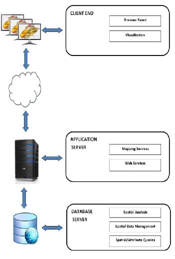
Fig.1. Web-GIS Architecture
3.2 Web-GIS System Architecture
Multi-tier architecture used to define step wise layers in developing any system. This research is also based on three major stages of client–server application architecture for presentation, processing, and data management. The first tier of this application emphasized on the client end like general public and the second tier used for mapping services and web based services. Similarly the third tier implanted for spatial analysis, spatial data management and for
spatial/attribute queries (Fig.1).
3.3 System Development Life Cycle (SDLC)
SDLC of this Web-GIS System adhere seven important stages essential for developers, such as Prerequisite and Planning, Installation and Configuration, Layering and Mapping, Customize Flexible Layout, Develop Functions, Testing, Implementation and Deployment are explained in the figure below. It defines assessment of present system, required tools and techniques, feasibility study and
IJSER © 2013 http://www.ijser.org
International Journal of Scientific & Engineering Research, Volume 4, Issue 11, November-2013 952
ISSN 2229-5518
validation of the system in running condition (Fig.2).
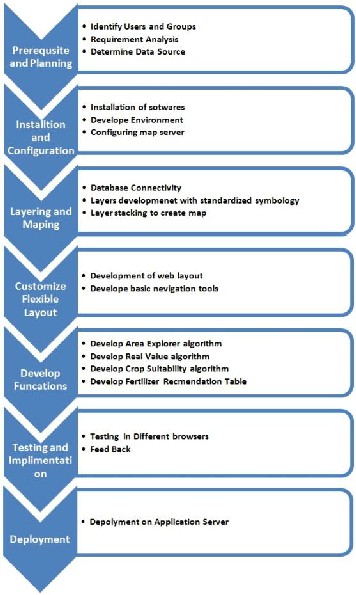
Fig.2. System Development Life Cycle
3.4 Functional Specification of System
System Use Case
Use Case Diagram is important to create before developing any system. It is simplest higher level view of a system which represents user interaction with system and define major tasks going to be performed by user. According to this appliaction, a user will be able to perform major functions like visualization of map with respect to different soil/water classifications, selection of desired layer of map, zooming and exploration of particular area, onclick crop suitability identifiication, view of fertilizer table and locating sample point by entering latitude and longitude (Fig.3).
IJSER © 2013 http://www.ijser.org
International Journal of Scientific & Engineering Research, Volume 4, Issue 11, November-2013 953
ISSN 2229-5518
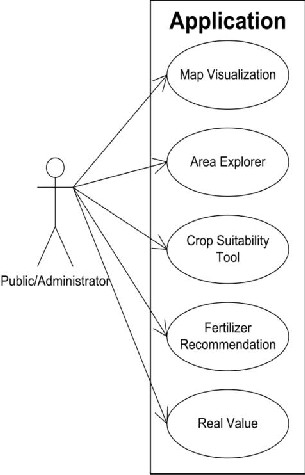
Fig.3. Use Case of Web-GIS System
Activity Flow Diagram
Activity flow diagram is a UML graphical representation of stepwise work-flow of any functions defining choice, concurrency and iteration in the functions. This research has four major tools which have particular workflows naming Crop suitability tool (Fig.4), Fertilizer recommendation tool (Fig.5), Area explore tool (Fig.6) and Real analyzed value tool (Fig.7).
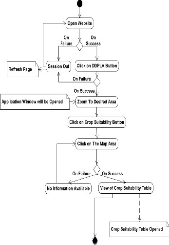
Fig.4. Activity flow Diagram of Crop Suitability tool
IJSER © 2013 http://www.ijser.org
International Journal of Scientific & Engineering Research, Volume 4, Issue 11, November-2013 954
ISSN 2229-5518
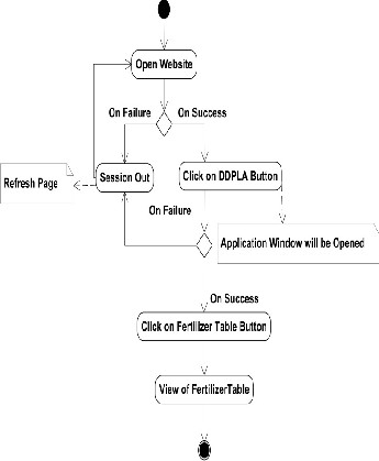
Fig.5. Activity flow Diagram of Fertilizer Recommendation
Tool
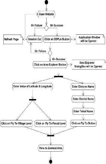
Fig.6. Activity flow Diagram of Area Explorer Tool
IJSER © 2013 http://www.ijser.org
International Journal of Scientific & Engineering Research, Volume 4, Issue 11, November-2013 955

ISSN 2229-5518
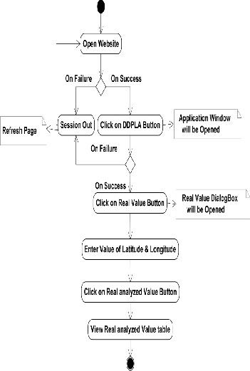 Fig. 8. Navigation Toolbar
Fig.7. Activity flow Diagram of Real Analyzed Value Tool
IJSER © 2013 http://www.ijser.org
International Journal of Scientific & Engineering Research, Volume 4, Issue 11, November-2013 956
ISSN 2229-5518
3.5 System Implementation
Map Visualization
Administrative boundaries of Tehsils of Punjab are overlapped on base maps.
Navigation
Fig.8 illustrating navigation toolbar used for selection, zoom in/out, fixed zoom in/out full extent and pan.
Legend
'Show Legend' function offers user to select/unselect desired layers. It emphasis on five types of classified datasets stored in SFRI database naming Soil Surfaces, Water Surfaces, Metrology Surfaces.
Area Explorer
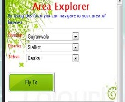
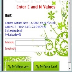
Fig.9 representing active condition of area explorer tool based on two processes. User can detect respective area of interest with the selection of division name, District name and Tehsil name or by entering Easting and Northing value.
Crop Suitability
On click identification tool of suitable crop of region
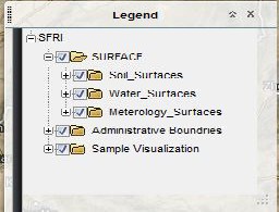
Available Surfaces in legend
selected from agricultural and of Punjab is displayed in Fig.10. This tool provides the soil analysis containing Electric Conductivity, pH, Texture, Organic Matter, Potassium, Phosphorus and ground water quality Analysis containing Electric, Residual Sodium Carbonate and Sodium Absorption Ratio of required area of interest in Punjab.
Fertilizer Recommendation
Fig.11 representing table view of recommended fertilizers for a particular arable land depends on its prescribed nature and chemical properties. Most of fertilizer needs based on nutrients deficiencies in soil parameters like Nitrogen, Phosphorous and Potassium.
Real Value
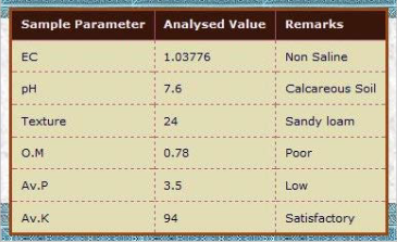
The validation process of analyzed value of sample collected from land with interpolated map surface results given by crop suitability tool explained in Fig.12. With the help of E and N values collected during sampling user can reanalyze his/her soil and water parameters.
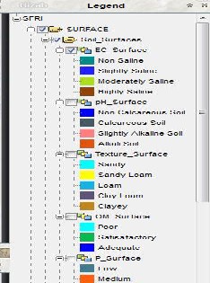
Selection of EC Surface from legend
IJSER © 2013 http://www.ijser.org
International Journal of Scientific & Engineering Research, Volume 4, Issue 11, November-2013 957
ISSN 2229-5518
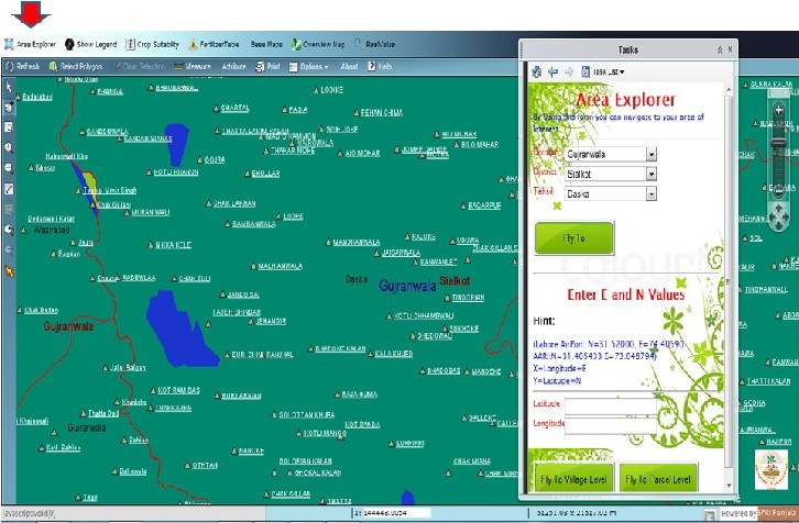
Fig.9. Zoom to area from Area Explorer
IJSER © 2013 http://www.ijser.org
International Journal of Scientific & Engineering Research, Volume 4, Issue 11, November-2013 958
ISSN 2229-5518
Fig.9a. Zoom using Division, Distric and Tehsil
Fig.9b. Zoom using E and N
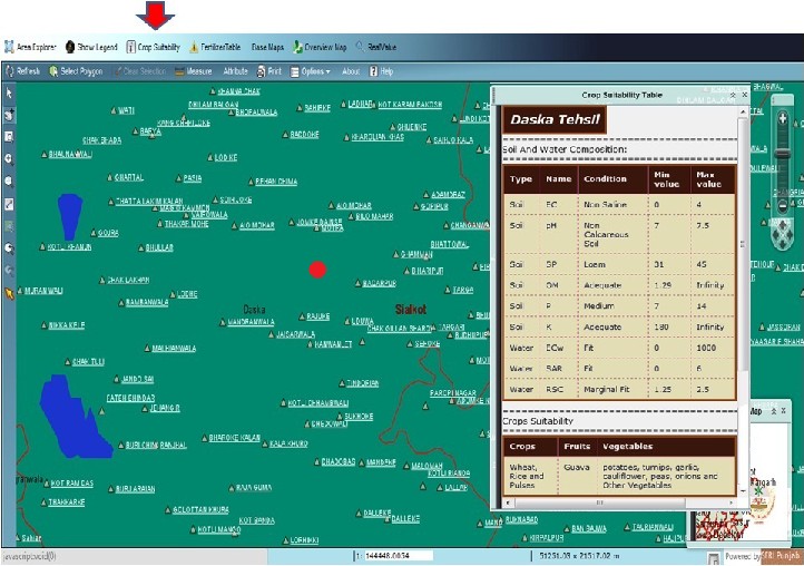
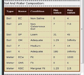
Fig.10. Crop suitability identification
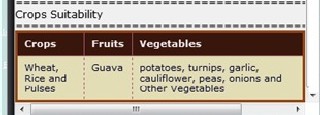
Fig.10a. Recommended Crop of selected area
IJSER © 2013 http://www.ijser.org
International Journal of Scientific & Engineering Research, Volume 4, Issue 11, November-2013 959
ISSN 2229-5518
Fig. 10b. Analyzed soil/water values of selected area
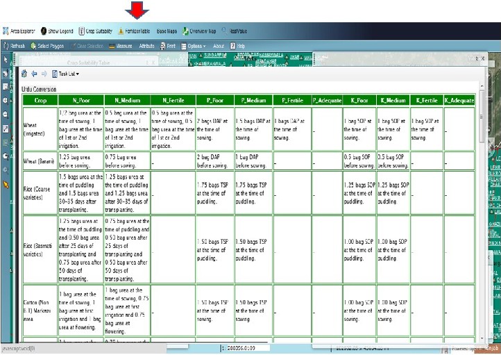
Fig.11. Fertilizer recommendation table view
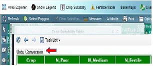
Fig.11a. Fertilizer recommendation table view in Urdu
IJSER © 2013 http://www.ijser.org
International Journal of Scientific & Engineering Research, Volume 4, Issue 11, November-2013 960
ISSN 2229-5518

Fig.12. Real value validation
International Journal of Scientific & Engineering Research, Volume 4, Issue 11, November-2013 961
ISSN 2229-5518
Fig. 12a. Analyzed value of sample
4 CONCLUSION
1. In agriculture countries like Pakistan, it is the basic need to develop awareness systems for
[8]
Society of America and American Society of
Agronomy [2004].
"Sustaining National Food Supply and Security", ESRI, Environmental Systems Research Institute, http://www.esri.com/industries/agriculture, 2012.
farmer.
2. GIS offered a large range of tools to build up a
Web-GIS system based on spatial database.
3. Focusing on main agriculture system, all resources are efficiently used to enlarge productivity by maintaining soil health.
4. Basic functions of crop suitability and
fertilizer recommendation are developed to facilitate a common grower and to assist decision makers to make practicable decisions.
REFERENCES
[1] "Land", Ministry for the Environment Manatū Mō Te Taiao, http://www.mfe.govt.nz/publications/ser/enz07- dec07/html/chapter9-land/page1.html, [2007].
[2] FAO. "Land Resources Evaluation and The Role of Land-related Indicators, by W.G. Sombroek", Land Quality Indicators and Their Use in Sustainable Agriculture and Rural Development, land and water bulletin, 5. Rome, [1997].
[3] "The Soil / Water Relationship". Washington Organic Recycling Council, http://www.compostwashington.org/index.php?option= com_content&view=article&id=57&Itemid=63, [2008
– 2013].
[4] FAO. "A Frame work for Land Evaluation", Soils
Bulletin, 32. Rome, [1993].
[5] "Agriculture in Pakistan", Wikipedia, The Free Encyclopedia, http://en.wikipedia.org/w/index.php?title=Agriculture_i n_Pakistan&oldid=567655856, [2013].
[6] H. Friedma, and P. McMichael, "Agriculture and the State System: The rise and decline of national agricultures, 1870 to the present, Sociologia Ruralis.Vol.XXIX-2, [1989], .93–117, available at http://devsoc.cals.cornell.edu/sites/devsoc.cals.cornell.e
du/files/shared/documents/agriculture%20and%20the
%20state%20system-pdf.pdf, [1989].
[7] J. Ryan., "Soil Fertility Enhancement in Mediterranean-type Dryland Agriculture: A Prerequisite for Development. In Challenges and Strategies of Dryland Agriculture", Crop Science
[9] "Technology Use in Agriculture-
GIS/GPS",Agricinghana, http://agricinghana.com/2013/07/16/technology-use-in- agriculture-gisgps [2013].
[10] R. Vernon, Knowing Where You’re Going: Information Systems for Agricultural Research Management, The Hague: International Service for National Agricultural Research [2001].
[11] "Web Soil Survey", USDA Natural Resources Conservation Service (NRCS), http://websoilsurvey.sc.egov.usda.gov/App/WebSoilSur
vey.aspx [2013].
[12] Jin-Yong Choi, Bernard A. Engel and Richard L.
Farnsworth., "Web-based GIS and spatial decision support system forwatershed management",. Journal of Hydroinformatics- 7 [2005],165-174.
[13] J. Liu et al., "WEB-GIS solution for rice cultivation management in Taiwan", ESRI Understanding Our World [2005].
[14] D. C. M. Corbett, "A Current Research Information System for the Management of Agricultural Research. R&D Management", Vol.19-3[1989], 251-263.
[15] W. Verheye et al, "Land Use, Land Cover and Soil
Sciences", The FAO Guidelines for Land Evaluation,
Vol-II.
IJSER © 2013 http://www.ijser.org


