—————————— ——————————
International Journal of Scientific & Engineering Research, Volume 6, Issue 3, March-2015 483
ISSN 2229-5518
A GIS Based Approach To Select Appropriate
Wastewater Treatment Technology A Case Study
– Shollinganallur Taluk Kanchipuram District
Tamil Nadu
K.Deepa, M.Krishnaveni, M.Mageshwari
Abstract— Shollinganallur Taluk of Kanchipuram District has been chosen as study area for the present research work which falls in the extension part of the peri-urban area of South Chennai city. The study area was facing problems of water scarcity and wastewater management. The wastewater generated in the study area is mainly disposed into nearby surface water bodies like ponds, lakes and low lying vacant lands, which create environmental pollution. The quality of surface water and groundwater were assessed during pre monsoon and post monsoon periods and compared with BIS water quality standards. The laboratory study revealed that Shollinganallur Taluk was facing environmental pollution problem. Thus in order to reduce the problems associated with the disposal of untreated wastewater, there is a need to identify advanced wastewater treatment technologies to provide improved sanitation for the people.
Index Terms — Geographical Information System, Overlay analysis, Decentralisation, Wastewater
—————————— ——————————
HE ultimate goal of Millennium Development Goals (MDGs) for the year 2015 “[5]” is to provide improved sanitation to the people and to access 100% sanitation for
the year 2025. Such improved sanitation will be attained through the concept of treatment of municipal wastewater using decentralised wastewater treatment system. Choukr- Allah and Hamdy (2004) defined that a technology which is affordable to and operable by the user provides the degree of purification needed for the wastewater’s end use”[2]”. BORDA (1998) proposed that the decentralized wastewater treatment system is an approach for treatment of municipal and indus- trial wastewater flow from 1 to 500 m3/day for community level“[1]”. Decentralized wastewater treatment system is a compactable approach and provides local control of wastewater (Kalbermattern John 1999)”[3]”. Hamadi Kallali et al (2007) identified suitable sites for soil aquifer treatment sys- tem using a GIS tool with single-objective multi-criteria analy- sis for groundwater recharge of Hammamet–Nabeul aquifer located in Cap Bon peninsula in North East of Tunisia”[4]”.
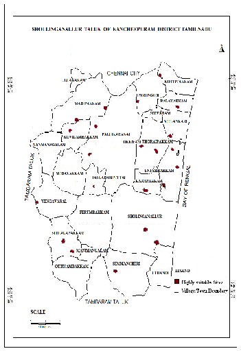
Shollinganallur Taluk comes under the administrative bound- ary of Kancheepuram district. The study area is located be- tween latitudes 12 15’ 20”N and 12 58’ 12”N and longitudes 80
9’12” and 80 16’9”E, covering a total area of 118 km2. The
physiographic units present in the study area (Figure 1) are
alluvial plain, hard rock areas and coastal plain. The present population of Shollinganallur Taluk as per 2011 Census is
3,33,534.
IJSER © 2015 http://www.ijser.org
International Journal of Scientific & Engineering Research, Volume 6, Issue 3, March-2015 484
ISSN 2229-5518
Selection of Wastewater
Treatment Technology
about 1.06 km2 and 9 DTP sites falling in rural area of about
1.03 km2 area. Based on the land availability and level I
landuse classification the recommendation of Up Flow Anaer-
obic Sludge Blanket (UASB) treatment technology for 15 DTP
sites in urban area and Constructed wetlands for 9 DTP sites
in rural area was suggested.
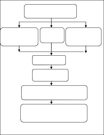
Survey of India map and Taluk map
ASTER Imager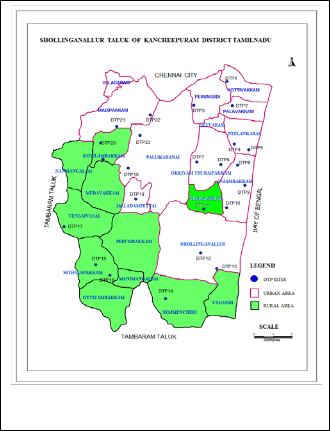
GPS Survey
Data
Collected in field
Geo-referncing
Thematic map layers creation
Overlay Analysis of Thematic Map
Layers in ARC/Info Software
Recommendation of suitable wastewater treatment technology for the treatment plant sites
Figure 2. Flow Chart Methdology for Selection of Suitable Wastewater Treatment Technology
Suggestion of suitable wastewater treatment technologies for favourable sites were done using a simple overlay analysis of the scoring of evaluation criteria and sub criteria maps with the constraint buffer zone maps in order to find areas where sites fall i.e whether in urban or rural landuse classification. Figure 3 shows the overlay of Decentralised Tratment Plant (DTP) sites map on landuse classification map of the study area. Among the 24 DTP sites, 9 DTP sites with identification number 11, 14, 16 17, 18, 21 and 24 fall in rural area classifica- tion and the remaining 15 DTP sites fall in urban area classifi- cation. It was found that total land area available around the DTP sites 11, 14, 16 17, 18, 21 and 24 which fall under the rural classification was 1.03 km2. Similarly the land available around DTP sites which fall under the urban classification was 1.03 km2. Selection of suitable wastewater treatment technology depends mainly on the type of wastewater quality generated from the study area, availability of land and climatic factors. The study area falls under semi arid climatic condition, the up flow anaerobic sludge blanket for urban area and constructed wet lands for rural area was suggested.
The overall analysis results showed that level I landuse classi- fication resulted 15 DTP sites falling in the urban area covering
Figure 3 Overlay map of DTP sites map on landuse map
[1] Bernd Gutterer, Ludwig Sasse, Thilo Panzerbieter and Thorsten Reck erzügel, “Decentralised Wastewater Treatment Systems (DEWATS) and Sanitation in Developing Countries”, A Practical Guide, BORDA 1998.
[2] Chouker Allah., R and Hamdy., A. “Wastewater Treatment and Reuse I
Morocco: Situation and perspectives”,International Workshop on Non-Conventional water use. Water saving in Mediterranean Agricul ture (WASAMED), 2004.
[3] Kalbermattern John, Richard Middleton and Roland”, The household
–centred environmental sanitation model”, SANDEC, Swiss Federal Institute for Environmental Science and Technology, Duebendorf, Switzerland, 1999.
[4] Hamadi Kallalia, Makram Ananea, Salah Jellalia, Jamila Tarhouni, GIS- based multi-criteria analysis for potential wastewater aquifer re
charge sites, Journal of Desalination, Vol. 215, pp. 111 - 119, 2007. [5] Tracking the Millennium Development Goals". MdgMonitor.
"The Millennium Development Goals: a cross-sectoral analysis and
principles for goal setting after 2015". The Lancet 376 (9745): 991–1023.
IJSER © 2015 http://www.ijser.org